News & announcements
Saving your history
Early accounts
Maps
Nearby towns
People
Churches
Schools
Municipal
Organizations
Businesses
The mines
Transportation
Streets
Buildings
Entertainment
Celebrations
Sports
Ethnic groups
Streets
What's on this page:
- Gallery of postcards showing street views
- Street names - partial history
- Then and now street views - new photos to match the views on old postcards, by Charlie Gallagher
- Around town in 1966 - photos by Ed Merrick
GALLERY OF POSTCARDS SHOWING STREET VIEWS
There were quite a few postcards produced back in the day
that
showed street views of Freeland. Some of them are reproduced here. If
you have any others, I would be interested in purchasing copies of
them. The view at the top of this page shows Centre Street looking
north from South Street, before Nocchi's and other buildings were torn
down to make way for new construction. A few of the older views
were provided
courtesy of J.
Zubach.
 Centre and
Walnut Streets, looking north. On the right is the Borough Building. On
the left, the building with the wood siding on the corner, is Lloyd's
millinery store, where ladies could purchase hats. This is a great view
of the Borough Building before the steeple was removed. I've got to
check my notes to see what that porch is in the left foreground. If you
know, I'd love to hear about it.
Centre and
Walnut Streets, looking north. On the right is the Borough Building. On
the left, the building with the wood siding on the corner, is Lloyd's
millinery store, where ladies could purchase hats. This is a great view
of the Borough Building before the steeple was removed. I've got to
check my notes to see what that porch is in the left foreground. If you
know, I'd love to hear about it.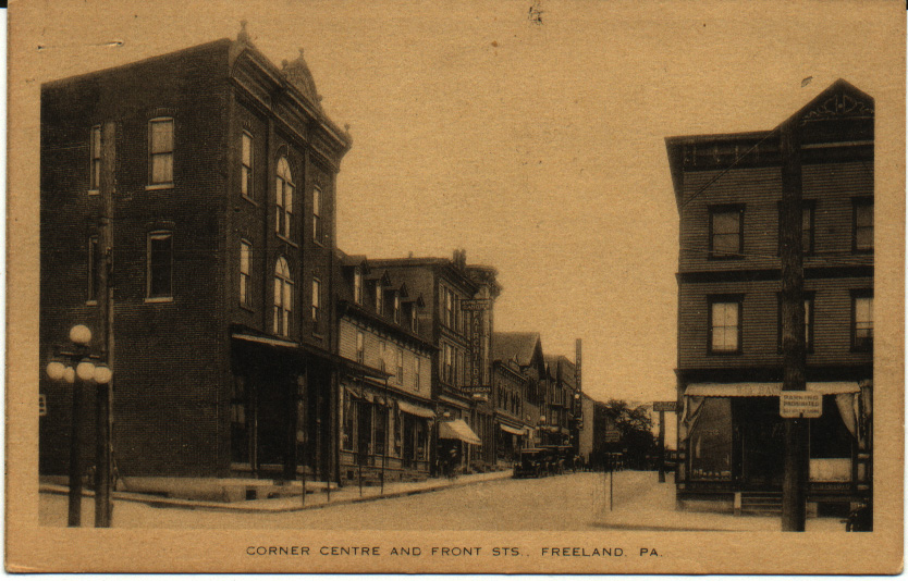 Centre and
Front Streets, looking north. On the right you see William
A. Bachman's optometrist office; he also dealt in watches and clocks at
the same location. On the left, on the corner, is Amandus Oswald's
general store. Two other signs are legible on the west side of the
street: "Home-made Candies - Fairchild's - Ice Cream" and "Light Heat
Power". Many of these buildings are
still standing and still identifiable.
Centre and
Front Streets, looking north. On the right you see William
A. Bachman's optometrist office; he also dealt in watches and clocks at
the same location. On the left, on the corner, is Amandus Oswald's
general store. Two other signs are legible on the west side of the
street: "Home-made Candies - Fairchild's - Ice Cream" and "Light Heat
Power". Many of these buildings are
still standing and still identifiable. Centre and
Main Streets, looking north. That's the Birkbeck Block in the left
foreground -- a large building which housed William Birkbeck's hardware
and plumbing business, and later a succession of other businesses.
Several early models of automobiles are on the street, and it's a
little hard to see but it's possible that there's a horse-drawn
carriage parked on the left behind the car that's in the foreground.
Centre and
Main Streets, looking north. That's the Birkbeck Block in the left
foreground -- a large building which housed William Birkbeck's hardware
and plumbing business, and later a succession of other businesses.
Several early models of automobiles are on the street, and it's a
little hard to see but it's possible that there's a horse-drawn
carriage parked on the left behind the car that's in the foreground.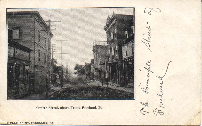 Looking
south from just above Centre and Front Streets. At the left of the
picture, in the foreground, is the print shop where the Semi-Weekly
Progress newspaper was printed. Across the street you can see Amandus
Oswald's general store on the corner, with its.covered entryway. There
are several trees visible on the next block, including the one or two
in front of the Central Hotel.
Looking
south from just above Centre and Front Streets. At the left of the
picture, in the foreground, is the print shop where the Semi-Weekly
Progress newspaper was printed. Across the street you can see Amandus
Oswald's general store on the corner, with its.covered entryway. There
are several trees visible on the next block, including the one or two
in front of the Central Hotel.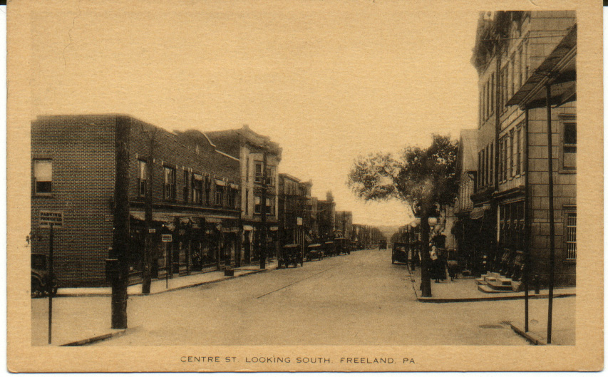 Centre and
Front Streets, looking southeast. On the right, the First
National Bank stands on the corner. I'm not sure, but I think
that the tree on the right is in front of the Central Hotel, which is
set back slightly and not visible in this view. Compare this view to
the next one, which shows the Central Hotel and the
Citizens Bank. Again, a number of these buildings are still there
and still recognizable. Notice the trolley tracks.
Centre and
Front Streets, looking southeast. On the right, the First
National Bank stands on the corner. I'm not sure, but I think
that the tree on the right is in front of the Central Hotel, which is
set back slightly and not visible in this view. Compare this view to
the next one, which shows the Central Hotel and the
Citizens Bank. Again, a number of these buildings are still there
and still recognizable. Notice the trolley tracks.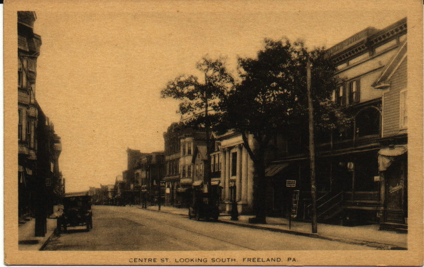 Centre Street,
looking southwest toward the Central Hotel and the Citizens Bank. Next
to the Central Hotel might be Steven B. Dvorshak's grocery and meat
market (it's a little hard to read the sign, but the location is about
right). Again, recognizable biuldings and
trolley tracks. The Central Hotel also contained a livery stable
and a number of other businesses that rented office or shop space from
the proprietor, M. H. Hunsicker.
Centre Street,
looking southwest toward the Central Hotel and the Citizens Bank. Next
to the Central Hotel might be Steven B. Dvorshak's grocery and meat
market (it's a little hard to read the sign, but the location is about
right). Again, recognizable biuldings and
trolley tracks. The Central Hotel also contained a livery stable
and a number of other businesses that rented office or shop space from
the proprietor, M. H. Hunsicker.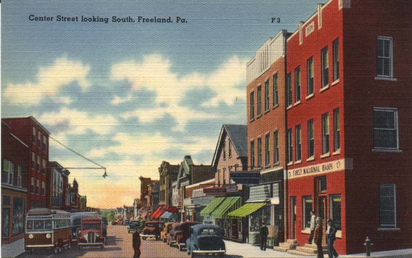 Another view
looking southeast at Centre Street from Front Street. On the right, the
First National Bank stands on the corner. No
more Central Hotel, no more trees, no trolley tracks, and look at the
cars and buses! Also notice the unusual street light on the
left side of the picture, hanging out over the street. Compare this
view to the one above of Centre and Front Streets, looking southeast.
Similar perspective, but a very different time period.
Another view
looking southeast at Centre Street from Front Street. On the right, the
First National Bank stands on the corner. No
more Central Hotel, no more trees, no trolley tracks, and look at the
cars and buses! Also notice the unusual street light on the
left side of the picture, hanging out over the street. Compare this
view to the one above of Centre and Front Streets, looking southeast.
Similar perspective, but a very different time period.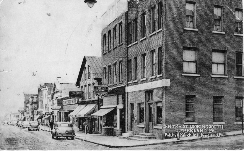 And yet
another view
looking southeast at Centre Street from Front Street. Look at how
similar this view is to the one just above! Fewer cars are on the
street, but the buildings are nearly identical. Genetti's grocery has
replaced the Central Hotel of earlier views, and the tree is gone. This
is another in the Fairchild's postcard series.
And yet
another view
looking southeast at Centre Street from Front Street. Look at how
similar this view is to the one just above! Fewer cars are on the
street, but the buildings are nearly identical. Genetti's grocery has
replaced the Central Hotel of earlier views, and the tree is gone. This
is another in the Fairchild's postcard series.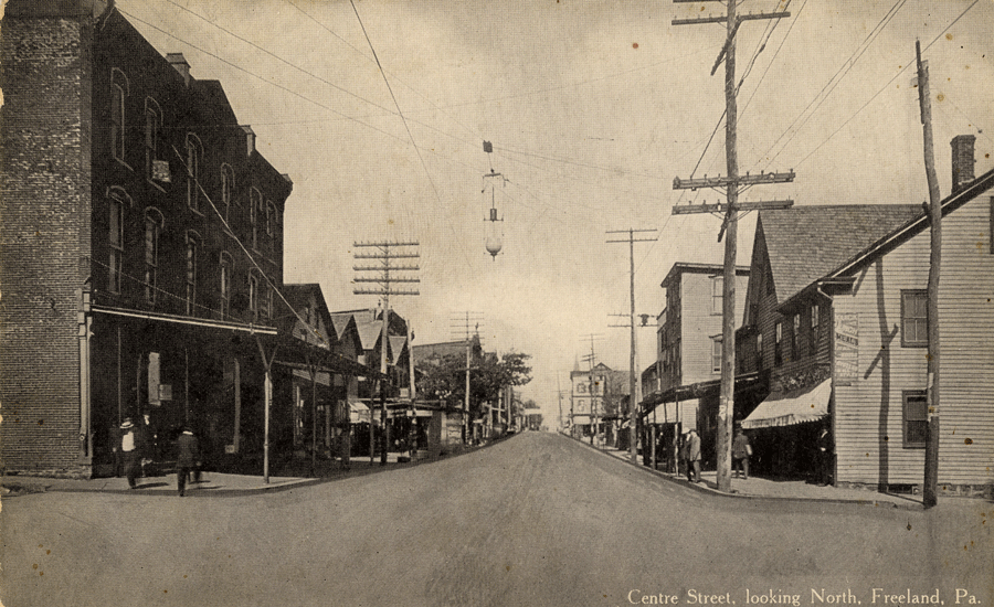 Centre and Main
Streets, looking north. On the left, on the corner, is the Birkbeck
block. The tree halfway up the block marks the location of the Central
Hotel. In the far distance at the top right you can see that
steeple on the Municipal Building. Many of the buildings visible in
this picture are still standing and still identifiable.
Centre and Main
Streets, looking north. On the left, on the corner, is the Birkbeck
block. The tree halfway up the block marks the location of the Central
Hotel. In the far distance at the top right you can see that
steeple on the Municipal Building. Many of the buildings visible in
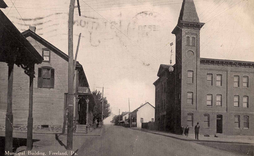
this picture are still standing and still identifiable.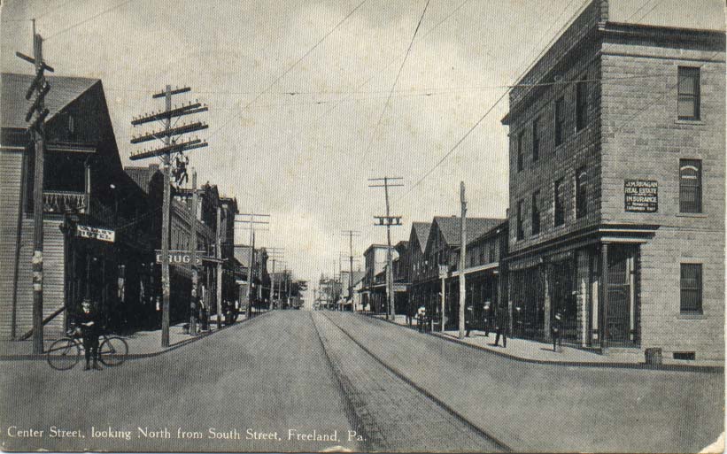 Centre
Street, looking north from South Street. This is a great picture,
especially in light of the recent new contruction on this site. In thie
photo, on the left in the foreground is the Valley Hotel (with a
balcony), and next to it a drug store. On the right
in the foreground, real estate and insurance offices. On the right,
all the way in the background, you can see what looks like a church
steeple. It's the borough building, which at this time still had a
steeple. See the photo on my "Municipal Matters" page.
Centre
Street, looking north from South Street. This is a great picture,
especially in light of the recent new contruction on this site. In thie
photo, on the left in the foreground is the Valley Hotel (with a
balcony), and next to it a drug store. On the right
in the foreground, real estate and insurance offices. On the right,
all the way in the background, you can see what looks like a church
steeple. It's the borough building, which at this time still had a
steeple. See the photo on my "Municipal Matters" page.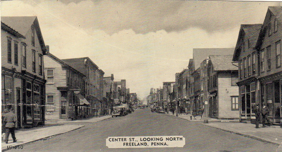 Centre
Street, looking north from Luzerne Street. Postcard from Ed Merrick,
photo taken around 1935-1936 (thank you to Mark Steward and Joni Nowak
Moses for dates). This is later than the one just below, as in this one
the trolley tracks have been removed. At front right we see 355 Centre,
which was Kasarda's saloon in the early 20th century and later the site
of Merrick's grocery store 1950-mid-1960s.
Centre
Street, looking north from Luzerne Street. Postcard from Ed Merrick,
photo taken around 1935-1936 (thank you to Mark Steward and Joni Nowak
Moses for dates). This is later than the one just below, as in this one
the trolley tracks have been removed. At front right we see 355 Centre,
which was Kasarda's saloon in the early 20th century and later the site
of Merrick's grocery store 1950-mid-1960s.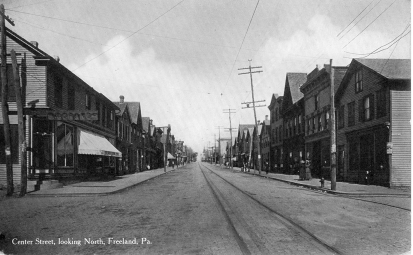 Centre
Street, looking north from Luzerne Street. Telephone poles
were sort of rough and ready, not as smoothly mass produced as they are
today. Note the trolley tracks going up Centre Street. No trees until
you get up to the Central Hotel on the left between Main and Front
Streets, barely visible here.
Centre
Street, looking north from Luzerne Street. Telephone poles
were sort of rough and ready, not as smoothly mass produced as they are
today. Note the trolley tracks going up Centre Street. No trees until
you get up to the Central Hotel on the left between Main and Front
Streets, barely visible here.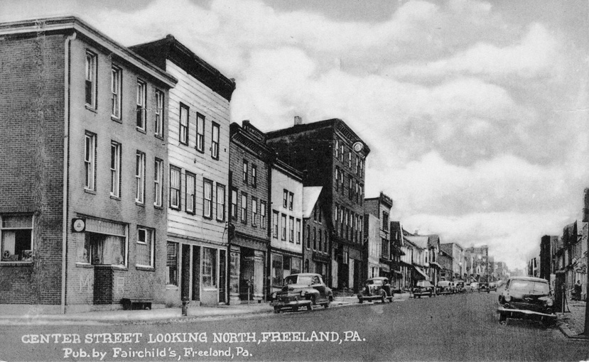 Centre
Street, looking north from Carbon Street. There's the Machella and
Resuto bar in the left foreground, a familiar site to me because it was
across the street from our apartment when I was a kid living above my
grandfather's auto supply store. This is another postcard in the
Fairchild's series.
Centre
Street, looking north from Carbon Street. There's the Machella and
Resuto bar in the left foreground, a familiar site to me because it was
across the street from our apartment when I was a kid living above my
grandfather's auto supply store. This is another postcard in the
Fairchild's series. Washington
Street, looking south from just above Main Street. Postcard
from Ed Merrick, photo taken late 1940s (thank you to Ed, Mark Steward
and Joni Nowak Moses for dates). Ed commented: "I remember those mature
trees to the left of St. Luke's because of the time I spent at my
grandparents' across the street and also because the Warners and the
Anthonys lived in the double houses behind them. I went to MMI with
Charles Chuck Warner and got to be friends with Ken Anthony, who was a
gifted artist." He also noted that it appears that it was
snowing
lightly when the photo was taken.
Washington
Street, looking south from just above Main Street. Postcard
from Ed Merrick, photo taken late 1940s (thank you to Ed, Mark Steward
and Joni Nowak Moses for dates). Ed commented: "I remember those mature
trees to the left of St. Luke's because of the time I spent at my
grandparents' across the street and also because the Warners and the
Anthonys lived in the double houses behind them. I went to MMI with
Charles Chuck Warner and got to be friends with Ken Anthony, who was a
gifted artist." He also noted that it appears that it was
snowing
lightly when the photo was taken. 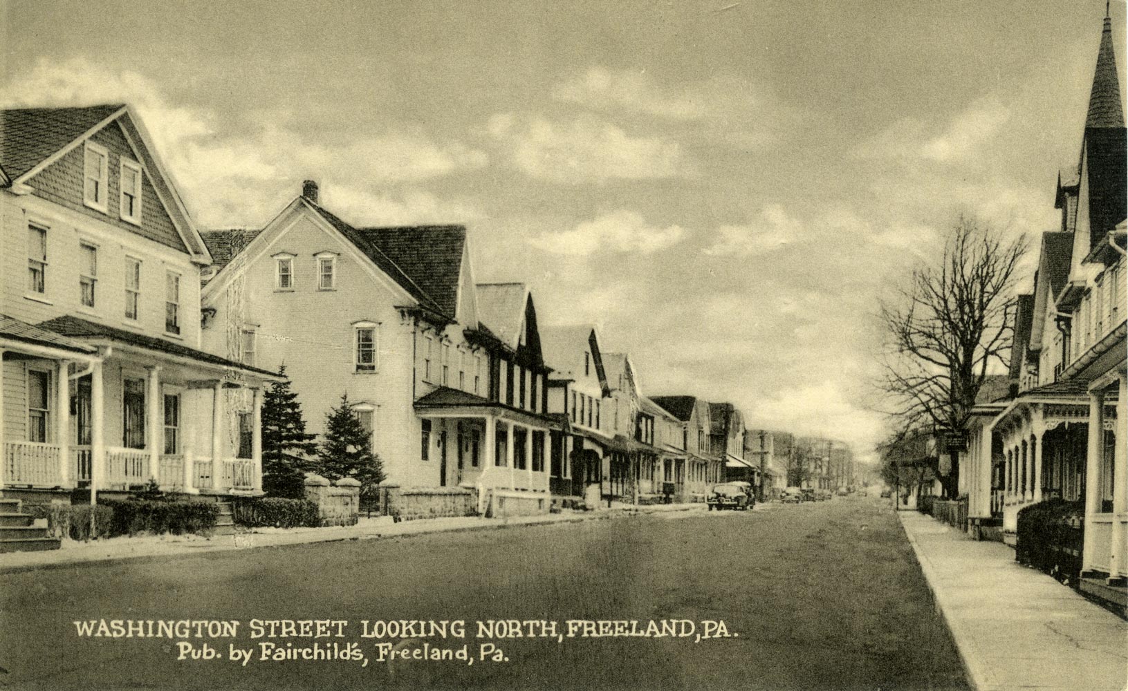 Washington
Street, looking north from just above Carbon Street, from Ed
Merrick. He writes: "You observed
that the utility poles had been
removed from the photo. It shows the DiSpirito residence on the left.
Farther up the street, a car is parked in front of 342 Washington
Street, and the car looks like our 1941 Buick. I am interested in
seeing the photo again to determine if there is any evidence of the
chestnut trees in the churchyard on the right." After looking at
the
photo again, he added: "I would bet
that they are the old chestnut
trees. Our house, at 342 with the car in front of it, is the one with
dark siding. The next houses down, the three-story houses with white
siding where the Hill, McElwee, and Sosnowski families lived, are
directly across the street from them, and note how much taller the
trees are."
Washington
Street, looking north from just above Carbon Street, from Ed
Merrick. He writes: "You observed
that the utility poles had been
removed from the photo. It shows the DiSpirito residence on the left.
Farther up the street, a car is parked in front of 342 Washington
Street, and the car looks like our 1941 Buick. I am interested in
seeing the photo again to determine if there is any evidence of the
chestnut trees in the churchyard on the right." After looking at
the
photo again, he added: "I would bet
that they are the old chestnut
trees. Our house, at 342 with the car in front of it, is the one with
dark siding. The next houses down, the three-story houses with white
siding where the Hill, McElwee, and Sosnowski families lived, are
directly across the street from them, and note how much taller the
trees are." STREETS RUNNING EAST-WEST:
 This view shows Walnut Street,
looking west toward Centre Street from a block or two east of it (from
Washington or Pine Streets?). The building at right in the foreground
looks like a storefront, but I only have this low resolution digital
photo and so I can't see enough detail to
be able to tell. You can see the steeple of the borough building in
the back right area of the photo.
This view shows Walnut Street,
looking west toward Centre Street from a block or two east of it (from
Washington or Pine Streets?). The building at right in the foreground
looks like a storefront, but I only have this low resolution digital
photo and so I can't see enough detail to
be able to tell. You can see the steeple of the borough building in
the back right area of the photo.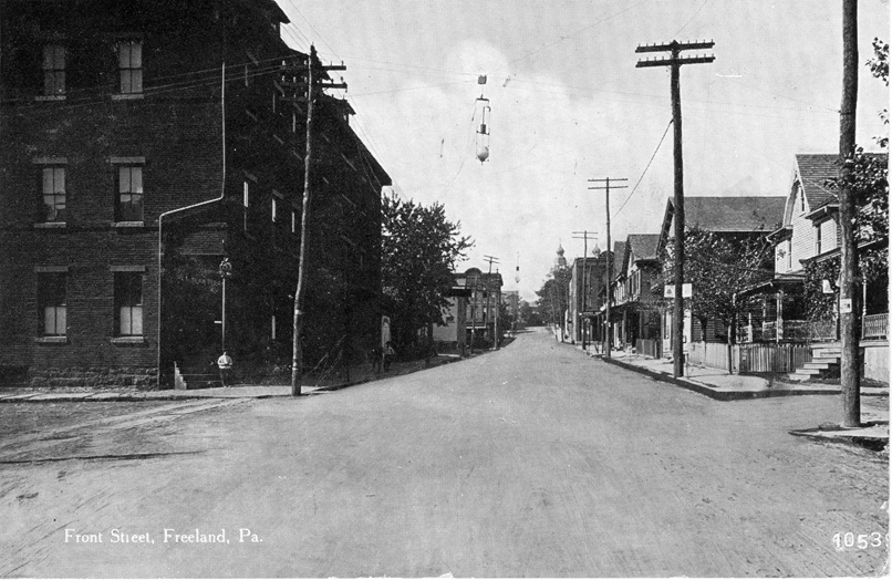 Front Street,
looking west toward Centre Street. I'm assuming that the large building
at left foreground is Krell's Hall, earlier the site of one of our
opera houses, and later the site of the A&P grocery store that
burned down in the 1970s. You can see the steeples of St.
Mary's Church in the back right area of the photo.
Front Street,
looking west toward Centre Street. I'm assuming that the large building
at left foreground is Krell's Hall, earlier the site of one of our
opera houses, and later the site of the A&P grocery store that
burned down in the 1970s. You can see the steeples of St.
Mary's Church in the back right area of the photo.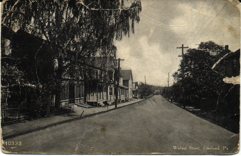 Here we're
looking east on Walnut Street toward Birkbeck Street, which you can see
at the end of the street. The buildings on this street
are mostly homes, as is the case today. There were some nice, large
trees along this street. The second building from the left edge of the
picture looks like a storefront of some kind, and has wooden doors
in the sidewalk in front that would lead to the basement.
Here we're
looking east on Walnut Street toward Birkbeck Street, which you can see
at the end of the street. The buildings on this street
are mostly homes, as is the case today. There were some nice, large
trees along this street. The second building from the left edge of the
picture looks like a storefront of some kind, and has wooden doors
in the sidewalk in front that would lead to the basement.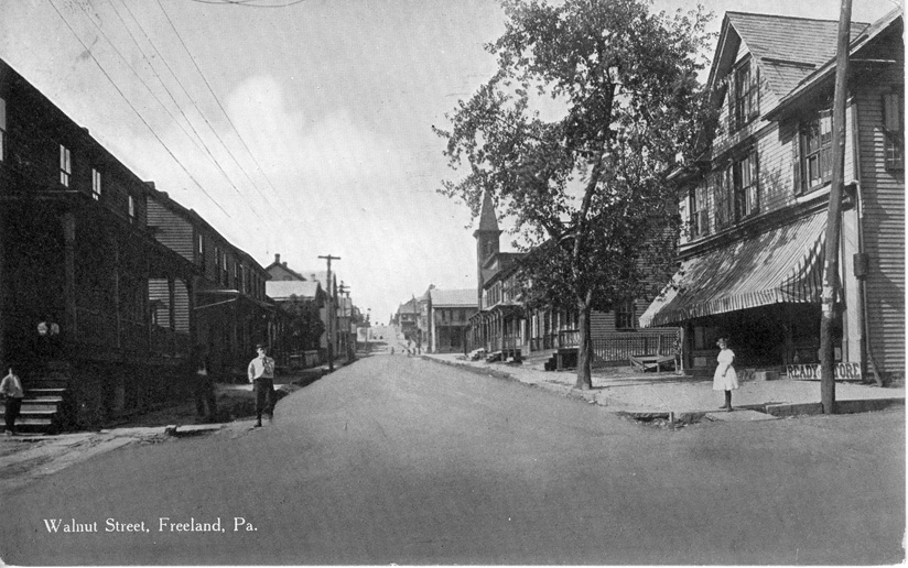 Walnut Street at Washington,
looking west toward Centre Street. You can see the steeple of the
Borough Building and the uphill rise of Walnut Street west of Centre.
That's Henry George's grocery store in the right foreground, shaded by
a large striped awning to protect people and produce from the heat of
the sun. I wonder how long that tree lasted before it was taken down?
Walnut Street at Washington,
looking west toward Centre Street. You can see the steeple of the
Borough Building and the uphill rise of Walnut Street west of Centre.
That's Henry George's grocery store in the right foreground, shaded by
a large striped awning to protect people and produce from the heat of
the sun. I wonder how long that tree lasted before it was taken down?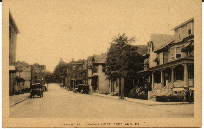 This is a great image, looking
toward the intersection of Centre and Front Streets from about a half
block east of the intersection, on Front Street. On the right you can
see the sign for Sharp's Bakery. At the intersection across Centre
Street you can see De Pierro's on the left (where the bank is now) and
Oswald's general store on the right. The twin steeples of St. Mary's
Church are visible in the background on the right. There were some
nice-sized trees along the street, too.
This is a great image, looking
toward the intersection of Centre and Front Streets from about a half
block east of the intersection, on Front Street. On the right you can
see the sign for Sharp's Bakery. At the intersection across Centre
Street you can see De Pierro's on the left (where the bank is now) and
Oswald's general store on the right. The twin steeples of St. Mary's
Church are visible in the background on the right. There were some
nice-sized trees along the street, too.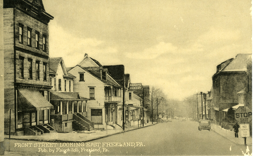 Here's
another Front Street view from a couple of decades later, standing at
the intersection of
Front and Centre Streets and looking east toward the Public Park
instead of west toward Ridge Street. There are several recognizable
buildings in
this photo. This is from a wonderful series of postcards produced by
Fairchild's.
Here's
another Front Street view from a couple of decades later, standing at
the intersection of
Front and Centre Streets and looking east toward the Public Park
instead of west toward Ridge Street. There are several recognizable
buildings in
this photo. This is from a wonderful series of postcards produced by
Fairchild's.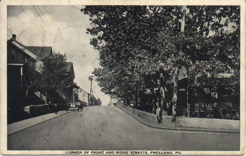 This postcard shows the
view from the intersection of Front and Ridge Streets, looking north
toward Walnut Street. This was a quiet residential area at the time of
the photo, even more so than it is today, and although you can't see it
here, the Bethel Baptist Church is at the end of the block ahead on the
right.
This postcard shows the
view from the intersection of Front and Ridge Streets, looking north
toward Walnut Street. This was a quiet residential area at the time of
the photo, even more so than it is today, and although you can't see it
here, the Bethel Baptist Church is at the end of the block ahead on the
right. 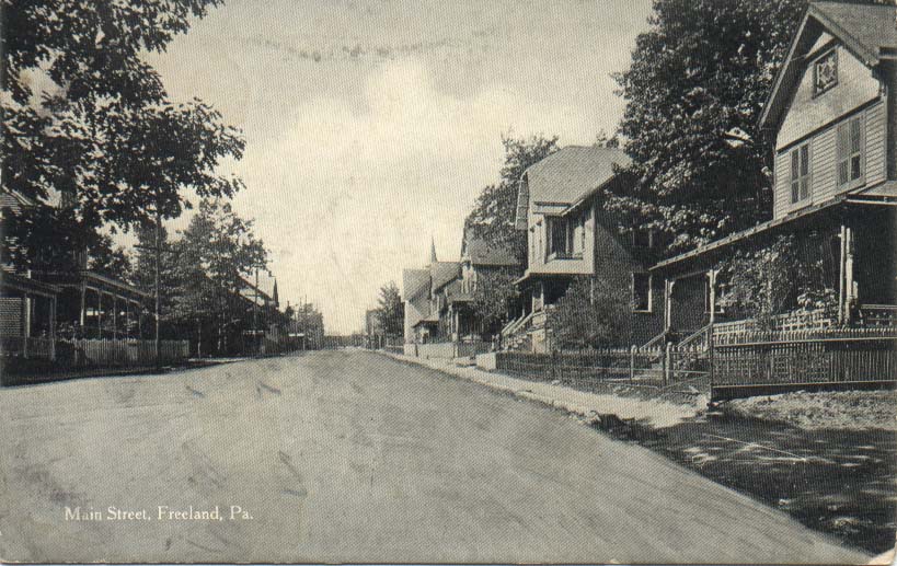 This
shows
some beautiful homes with fenced lawns and yards, and quite a few trees
along the street. The church steeple visible at right in
the background is the original St. Luke's Lutheran Church, a wooden
building that was later replaced by stone construction. I can't tell
what's at the far end of the street -- trees? The Public Park is behind
the person who photographed this view.
This
shows
some beautiful homes with fenced lawns and yards, and quite a few trees
along the street. The church steeple visible at right in
the background is the original St. Luke's Lutheran Church, a wooden
building that was later replaced by stone construction. I can't tell
what's at the far end of the street -- trees? The Public Park is behind
the person who photographed this view.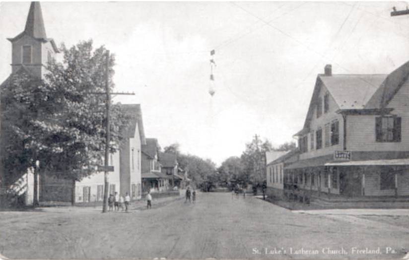 Here's
another view from about a block up the street and facing the other
direction, toward the park. The original St. Luke's is on the left, and
the Cottage Hotel is on the right. This is another one that I only have
this one low-resolution digital image of, and so I can't provide better
detail at present. Still, it's enough to give you a sense of what that
neighborhood looked like.
Here's
another view from about a block up the street and facing the other
direction, toward the park. The original St. Luke's is on the left, and
the Cottage Hotel is on the right. This is another one that I only have
this one low-resolution digital image of, and so I can't provide better
detail at present. Still, it's enough to give you a sense of what that
neighborhood looked like.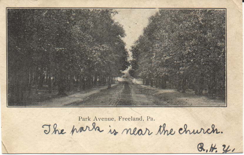 This is kind
of an odd view. It shows an unpaved roadway through the park, looking
westward toward the east end of Main Street, where the Park M. E.
Church is. The caption of this postcard says, "Park Avenue, Freeland,
Pa." You can see that at this time the park was still
rather densely wooded.
This is kind
of an odd view. It shows an unpaved roadway through the park, looking
westward toward the east end of Main Street, where the Park M. E.
Church is. The caption of this postcard says, "Park Avenue, Freeland,
Pa." You can see that at this time the park was still
rather densely wooded.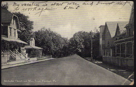 In this view,
the photographer was standing about a half block west of the Park M. E.
Church, facing east toward the Public Park. You can see the church, the
last building on the right. The postmark on this postcard is dated
1912, so while we don't know what year this photo was taken, we at
least know that it's no later than 1912.
In this view,
the photographer was standing about a half block west of the Park M. E.
Church, facing east toward the Public Park. You can see the church, the
last building on the right. The postmark on this postcard is dated
1912, so while we don't know what year this photo was taken, we at
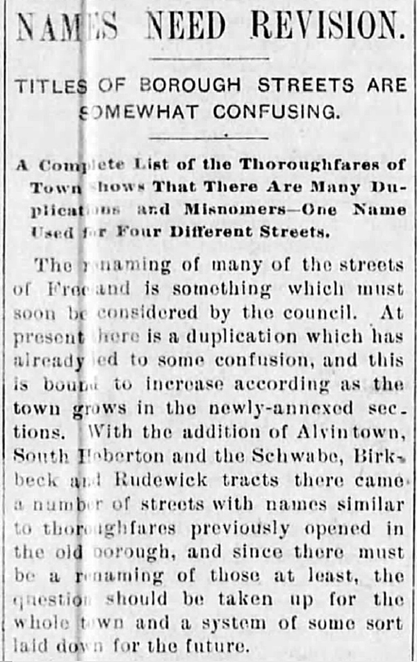
least know that it's no later than 1912.STREET NAMES NEED REVISION (1897 article):
Ed Merrick found this 1897 article about the confusion in duplicative street names that ensued in the wake of the big annexation that joined South Heberton, Birvanton and Alvinton to Freeland.
CITIZENS HONORED BY NAMING OF STREETS (1926 article):
I have a clipping from what I assume is one of the Hazleton
newspapers. The name of the paper isn't on the clipping; the article
has the heading, "News of the North Side", and someone has
written in ink, "4-26-26". The article names 6 Freeland streets
and says who each is named for.
Freeland Honors Its Citizens
That the people of Freeland have the faculty of apreciating worth and public services is seen in the names of many local streets.
Birkbeck street has been so named as a public recognition of Joseph Birkbeck and brother Thomas, who did much to build up the town.
Schwabe street is a memorial to the life and labors of the late Mathias Schwabe.
Johnson street has been so named as a tribute to William Johnson, also deceased, who was one of the town's pioneer residents.
Alvin street and that section of the town known as "Alvington" has been so named as a tribute to Alvin Markle, who is still much alive and a prominent Hazleton banker and traction magnate.
Burton street has been so named to commenorate the life and labors of John Burton, now deceased.
Meehan street in Foster Township is so named as a
tribute to contractor Patrick Meehan, now retired, but very much alive,
a man who built more foundaton walls in Freeland than any other
contractor.
Cunnius street is surely named for John M. Cunnius, proprietor of the Freeland Planing mill.