News & announcements
Saving your history
Early accounts
Maps
Nearby towns
People
Churches
Schools
Municipal
Organizations
Businesses
The mines
Transportation
Streets
Buildings
Entertainment
Celebrations
Sports
Ethnic groups
Freeland and area maps - Introduction
What's on this page about Freeland:
- Topographic maps
- Highway maps
- Railroad maps
- Satellite maps
- Sanborn Fire Insurance maps
- Aerial photos
- Pennsylvania Mine Map Atlas
- Various other Pennsylvania maps
The pages in this section contain views of the Freeland area from a variety of maps and aerial views, produced from 1870 to the present. Different types of views give different perspectives and different kinds of information. In some cases I own the originals or copies, and in other cases I'm linking to them on other sites. Site contributor Charlie Gallagher has sent numerous links and descriptions of maps and map-like views, and some of those are available here. The point is to let us all see how the area has changed over time, how roads and railroad lines have come and gone, and how local communities have been interconnected at different times so that people could travel from one place to another, from late 19th century up to the present day. As with so much else in life, no one piece gives the whole view.
Topographic maps
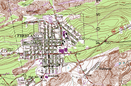
The United States Geological Survey is the scientific arm of the Department of the Interior, and it surveys the landscape of the U.S. to collect data on natural resources and other aspects. The USGS produces topographic maps of all parts of our country. A key feature of topographic maps is their ability to show features such as elevation in a clear way.I'm providing links here to a site called TopoQuest that provides a topographic map viewer that enables you to look at USGS maps and zoom in on details and easily switch to another map. Each time you click on a spot on one of these maps, you get a closer view. Here are links to two of them, and on the site you'll find links to others for nearby communities.
Freeland
Hazleton
For the Freeland map, click on the shape of Freeland on the lower right corner area of the map to get a closer view; do that several times to get to a large enough view to show details. Also, beneath the map is a list of "Places Within This Map View." So for the Freeland map that list includes the Freeland Lookout Tower, Saint Ann Cemetery, Upper Lehigh, Youngstown, and the Honey Hole.
Railroad maps
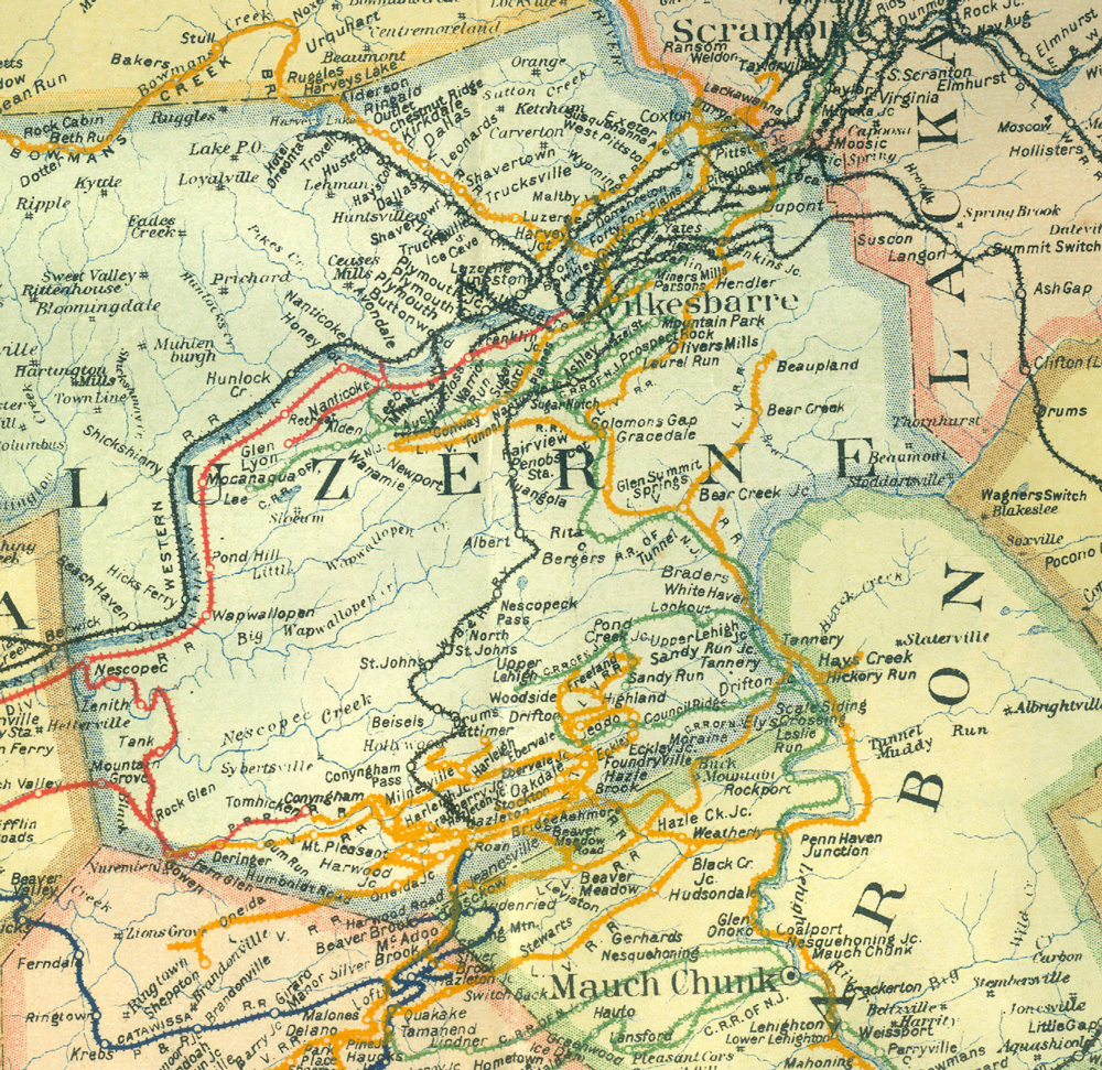
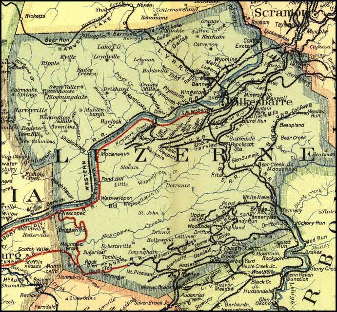
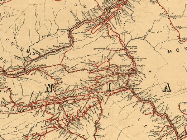 I'm
on the lookout for better copies of these or similar area railroad
maps. The leftmost map is dated 1871. The 1895 map at center comes from
Charlie Gallagher, titled "1895 Luzerne Railroad Map", and the 1911 map
on the right comes from my brother Steve. These maps show the
kind of documentation that was being made to trace the railroads as
they expanded across the state.
I'm
on the lookout for better copies of these or similar area railroad
maps. The leftmost map is dated 1871. The 1895 map at center comes from
Charlie Gallagher, titled "1895 Luzerne Railroad Map", and the 1911 map
on the right comes from my brother Steve. These maps show the
kind of documentation that was being made to trace the railroads as
they expanded across the state. Elsewhere, the Pennsylvania State Archives has a page about railroad maps available in the Archives.
And meanwhile, another kind of retrospective railroad mapping is linked in the "Satellite maps" section below.
Highway maps
This link to Pennsylvania Highways - Official State Highway Maps comes to us from Charlie Gallagher. You'll see that there are PDFs available for a few maps: 1940, 1950, 1960, 1970, 1980, 1989A. Maybe the site owner will digitize more of them later. As Charlie points out, the 1940 map shows the old 940, which isn't the same as the current 940. Thanks to Charlie, and to Jeffrey J. Kitsko, who made that website.Another page, signed Harold Cramer, contains links to images of Pennsylvania in old road atlases, 1890-1930, with some information about the road atlases.
There's a page on the PA Department of Transportation site that makes a number of transportation-related maps available in PDF: Tourism and transportation maps; County maps; Township, borough and city maps; Traffic volume maps; and Pennsylvania maps.
Sanborn Fire Insurance maps
The Sanborn Fire Insurance Company has created these maps to track where every building was, what their general characteristics were, what the addresses were, whether a building was a dwelling or a business or something else, and so on. I think they made them for every community with a population of 5,000 or more, but I'll have to double check that. So while there are not Sanborn maps for the smaller communities around Freeland, there are these maps for Freeland and they are amazing.As noted on their website, Penn State has a nearly complete collection of Sanborn Fire Insurance maps for Pennsylvania. The Library of Congress originally collected these maps for the whole country, and there is a good guide on the LC website for how to interpret the color coding and labeling used on the maps.
Aerial photos
Both Charlie Gallagher and Bill
Kovalick originally sent a link to what was then Penn State's Penn
Pilot project for making aerial photos accessible, sponsored by the
Pennsylvania Geological Survey. The Penn
Pilot website provided access to thousands of aerial photos created by
the USDA. Joe Moore alerted me more recently to the fact that the Penn Pilot photos are no longer accessible in the way they had been. You can use this link to a PA historic preservation site to access them.