
News & announcements
Saving your history
Early accounts
Maps
Nearby towns
People
Churches
Schools
Municipal
Organizations
Businesses
The mines
Transportation
Streets
Buildings
Entertainment
Celebrations
Sports
Ethnic groups
Central Hotel
What's on this page:
- Three postcard views of the Central Hotel
- Maps of that block of Centre Street from 1895 and 1912
- Text of two newspaper
notices about the hotel
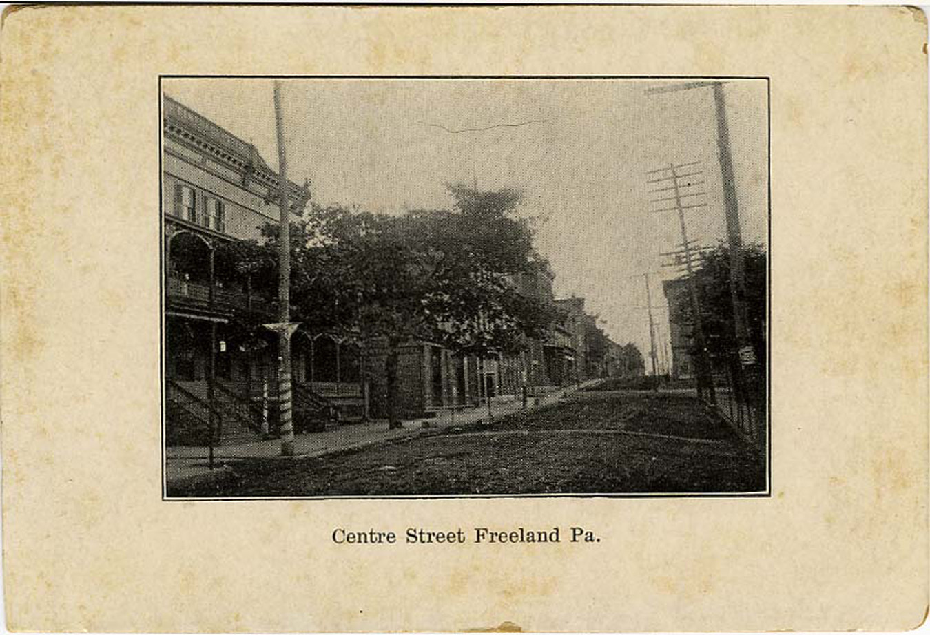 The Central Hotel was
built in the late 1870s and was still in use in the 1930s. Being right
in the center of town and the business district was advantageous,
and its porch, fountain and shade tree gave the hotel a comfortable air
of
distinction. The view at left shows unpaved streets with trees
on both sides of the
street. A
sign on the tree in front of the hotel says "Central Hotel." On this
early picture of the hotel, there are two sets of stairs going up to
the porch. By the time of the next picture, below, the left set of
stairs has been replaced by what looks like a small storefront or
office. The entrance to the small
alley along the south side of the hotel building is visible at lower
left of the photo.
Looking up the street, you see where the northeast corner of Centre and
Front streets juts further into the street than the blocks to the south
of it do. Across Centre Street at that corner is Amandus Oswald's
general store - it has
a roof over its entrance held up by poles, barely visible on this card.
The Central Hotel was
built in the late 1870s and was still in use in the 1930s. Being right
in the center of town and the business district was advantageous,
and its porch, fountain and shade tree gave the hotel a comfortable air
of
distinction. The view at left shows unpaved streets with trees
on both sides of the
street. A
sign on the tree in front of the hotel says "Central Hotel." On this
early picture of the hotel, there are two sets of stairs going up to
the porch. By the time of the next picture, below, the left set of
stairs has been replaced by what looks like a small storefront or
office. The entrance to the small
alley along the south side of the hotel building is visible at lower
left of the photo.
Looking up the street, you see where the northeast corner of Centre and
Front streets juts further into the street than the blocks to the south
of it do. Across Centre Street at that corner is Amandus Oswald's
general store - it has
a roof over its entrance held up by poles, barely visible on this card.  I'm not sure of the date
of this second postcard view, although the handwriting suggests that
the photo was taken not later than 1909. The bank building that would
be built just on the other
side of the alley was not yet there. This is a fabulous front view of
the entire hotel building (a cropped view is at the top left of this
page). There is someone sitting on the porch,
there's a
young
child in white clothes on the sidewalk in front at right, and it looks
like three boys
in front at left, possibly standing around the fountain. That might be
a porch swing visible at
the right end of
the porch. Look between the buildings where the alley is and I *think*
you can
see the older St. Mary's Church - at least to my eye it looks like one
of the steeples on the middle
church in this photo
that was made before the school was there.
I'm not sure of the date
of this second postcard view, although the handwriting suggests that
the photo was taken not later than 1909. The bank building that would
be built just on the other
side of the alley was not yet there. This is a fabulous front view of
the entire hotel building (a cropped view is at the top left of this
page). There is someone sitting on the porch,
there's a
young
child in white clothes on the sidewalk in front at right, and it looks
like three boys
in front at left, possibly standing around the fountain. That might be
a porch swing visible at
the right end of
the porch. Look between the buildings where the alley is and I *think*
you can
see the older St. Mary's Church - at least to my eye it looks like one
of the steeples on the middle
church in this photo
that was made before the school was there.
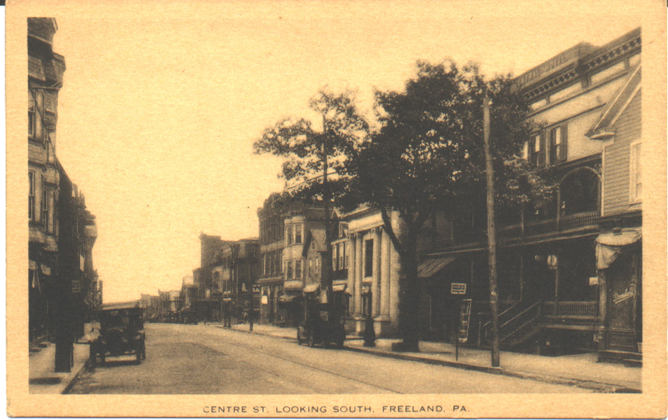 This third postcard
shows how the view changed as time progressed. The Citizens Bank is now
in place, and there are automobiles parked on the street. A sign
hanging on the hotel porch indicates that they have telephone service.
Although today the hotel building is long gone, a number of the other
buildings shown in this photo are still standing and are recognizable.
Note the trolley
tracks.
This third postcard
shows how the view changed as time progressed. The Citizens Bank is now
in place, and there are automobiles parked on the street. A sign
hanging on the hotel porch indicates that they have telephone service.
Although today the hotel building is long gone, a number of the other
buildings shown in this photo are still standing and are recognizable.
Note the trolley
tracks.
1895 Sanborn Fire Insurance Map showing the block where the Central Hotel was located
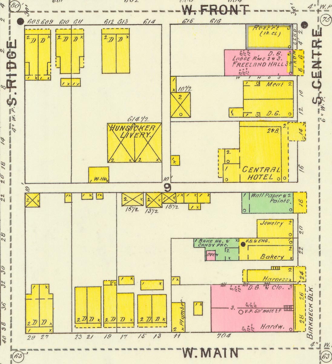 This might be
roughly the same time as the first postcard shown above was made.
Milton H. Hunsicker was listed as the hotel proprietor in the 1895
Barry's city directory. Thomas Hunsicker, a veterinary surgeon, had a
livery stable in the building behind the hotel. Both men lived at the
hotel. Michael Rondinelli had a barbarshop on the hotel premises.
Alfred A. Bachman had a wall paper store next door on the site where
the bank would later be built; the Citizens Bank at this time was on
Front Street. Looking south, next to the wall paper shop was William
Keiper, jeweler and watchmaker;
next to that, John B. Laubach, confectioner and baker. George Wise,
harnessmaker was next to the bakery, and then there was the large
building at Centre and Main streets known as the Birkbeck Block.
Besides William Birkbeck's hardware store it contained several other
businesses as well as the Mining and Mechancal Institute, relocated
here after a fire
destroyed the original building in Drifton. Meanwhile, looking up the
street from
the hotel was Joseph Neuburger's dry goods store, a meat market, the
Freeland Hall, and a restaurant (possibly DePierro Bros., listed as
being on that corner
in 1897) at the location where another the First National Bank would
later be built.
This might be
roughly the same time as the first postcard shown above was made.
Milton H. Hunsicker was listed as the hotel proprietor in the 1895
Barry's city directory. Thomas Hunsicker, a veterinary surgeon, had a
livery stable in the building behind the hotel. Both men lived at the
hotel. Michael Rondinelli had a barbarshop on the hotel premises.
Alfred A. Bachman had a wall paper store next door on the site where
the bank would later be built; the Citizens Bank at this time was on
Front Street. Looking south, next to the wall paper shop was William
Keiper, jeweler and watchmaker;
next to that, John B. Laubach, confectioner and baker. George Wise,
harnessmaker was next to the bakery, and then there was the large
building at Centre and Main streets known as the Birkbeck Block.
Besides William Birkbeck's hardware store it contained several other
businesses as well as the Mining and Mechancal Institute, relocated
here after a fire
destroyed the original building in Drifton. Meanwhile, looking up the
street from
the hotel was Joseph Neuburger's dry goods store, a meat market, the
Freeland Hall, and a restaurant (possibly DePierro Bros., listed as
being on that corner
in 1897) at the location where another the First National Bank would
later be built.
1912 Sanborn Fire Insurance Map showing the block where the Central Hotel was located
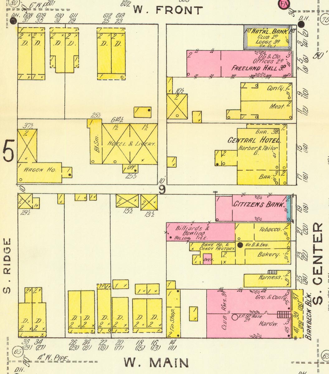 Looking at this
map you can see some of the change that came to this block in the 17
years
since 1895.
Behind the hotel, in addition to the livery, there is a blacksmith
shop, and in a
new building behind that there is a wagon house. On the hotel premises
there are a
barber, a tailor, and two bars. Across the small alley now stands the
new Citizens Bank. Next to that, in place of the little jewelry and
watch shop there is now a larger building containing a tobacco shop in
front and a billiards hall and bowling alley behind. There's still a
bakery
and confectionery next to that, then the Wise harness shop as before.
On the corner stands the Birkbeck Block containing a grocery and
confectionery
and the hardware store, plus some other offices and club rooms. The
Mining and Mechanical Institute has been relocated to a new building at
their current location south of Carbon Street. And meanwhile, looking
up the street from
the hotel you now see a meat shop, another candy shop, the Freeland
Hall (expanded by a 2-story addition at the back) and another new bank
building, the First National Bank.
Looking at this
map you can see some of the change that came to this block in the 17
years
since 1895.
Behind the hotel, in addition to the livery, there is a blacksmith
shop, and in a
new building behind that there is a wagon house. On the hotel premises
there are a
barber, a tailor, and two bars. Across the small alley now stands the
new Citizens Bank. Next to that, in place of the little jewelry and
watch shop there is now a larger building containing a tobacco shop in
front and a billiards hall and bowling alley behind. There's still a
bakery
and confectionery next to that, then the Wise harness shop as before.
On the corner stands the Birkbeck Block containing a grocery and
confectionery
and the hardware store, plus some other offices and club rooms. The
Mining and Mechanical Institute has been relocated to a new building at
their current location south of Carbon Street. And meanwhile, looking
up the street from
the hotel you now see a meat shop, another candy shop, the Freeland
Hall (expanded by a 2-story addition at the back) and another new bank
building, the First National Bank.