News & announcements
Saving your history
Early accounts
Maps
Nearby towns
People
Churches
Schools
Municipal
Organizations
Businesses
The mines
Transportation
Streets
Buildings
Entertainment
Celebrations
Sports
Ethnic groups
1873 Atlas maps of nearby towns and townships
What's on this page:
- 1873 Atlas maps - Boroughs and villages, Townships,
Supplemental information
- Links to more 1873 Atlas maps of Luzerne County - offsite, Rootsweb site at Ancestry.com
- Links
to more 1873 Atlas
maps of Luzerne County - offsite,
US GenWeb Archives site
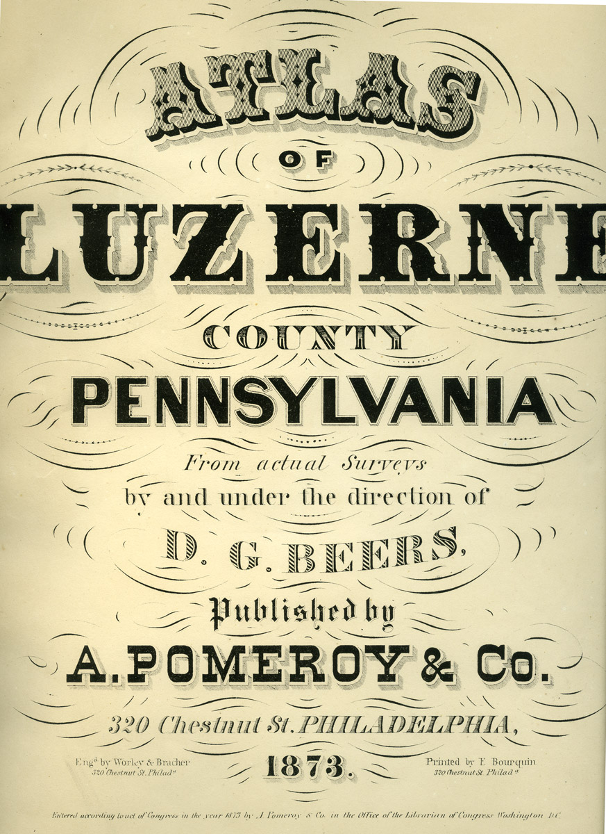 The maps
shown
on this page come from The Atlas
of Luzerne County, published in 1873. The maps were made from
surveys done under the supervision of D. G. Beers, and the atlas was
published in Philadelphia. Here at left are the front cover and the
title page - the book is too large for my scanner, and so the title
page is shown minus the blank space around the text. Still, these
photos show the elegant presentation style of this atlas.
The maps
shown
on this page come from The Atlas
of Luzerne County, published in 1873. The maps were made from
surveys done under the supervision of D. G. Beers, and the atlas was
published in Philadelphia. Here at left are the front cover and the
title page - the book is too large for my scanner, and so the title
page is shown minus the blank space around the text. Still, these
photos show the elegant presentation style of this atlas.This atlas was made just 8 years after the end of the Civil War, and 7 years before Munsell published his History of Luzerne, Lackawanna and Wyoming Counties, Pa. in 1880. It would be another 3 years before Freeland would be incorporated as a borough. The text below was excerpted from W. W. Munsell's History of Luzerne, Lackawanna and Wyoming Counties, Pa. (1880).
Boroughs and villages
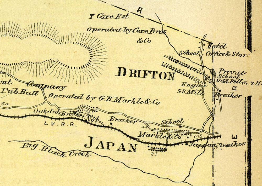 Drifton and Japan -
"Drifton, like Upper Lehigh, is a neat little town, and in appearance
an exception to the general rule in the mining districts. It has one
hotel, three churches -- Protestant Episcopal, Methodist Episcopal and
Roman Catholic; an opera house, built by Coxe Bros. for the use of
their employees; a company store, school-house, railroad depot, "Major
Charles S. Coxe Post G. A. R.," several civic societies and about 1,000
inhabitants. The town is well supplied with water, brought in pipes
from a hill near by. Cross Creek collieries No. 1 and 2 are located at
t his place, and owned and operated by Coxe Bros. & Co. The mines
in 1878 yielded 285,320 tons of coal."
Drifton and Japan -
"Drifton, like Upper Lehigh, is a neat little town, and in appearance
an exception to the general rule in the mining districts. It has one
hotel, three churches -- Protestant Episcopal, Methodist Episcopal and
Roman Catholic; an opera house, built by Coxe Bros. for the use of
their employees; a company store, school-house, railroad depot, "Major
Charles S. Coxe Post G. A. R.," several civic societies and about 1,000
inhabitants. The town is well supplied with water, brought in pipes
from a hill near by. Cross Creek collieries No. 1 and 2 are located at
t his place, and owned and operated by Coxe Bros. & Co. The mines
in 1878 yielded 285,320 tons of coal." "Japan is a small mining town, of about 400 population; with a store and school-house."
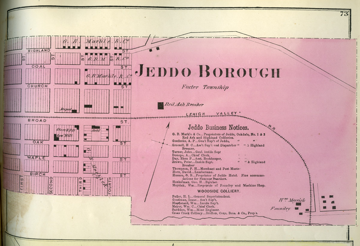 Jeddo
- "Jeddo borough was formed from Foster and Hazle townships, Oct. 23rd,
1871; its population is 350. Here is the Woodside colliery, owned by
the Jeddo Coal Company and operated by Coxe Bros. & Co. ... The
Jeddo and Carbon County Railroad Company was chartered March 23d, 1854;
the name changed to Lehigh and Luzerne Railroad Company February 12th,
1856, and it was merged in the Lehigh Valley Railroad Company June
16th, 1868. About one mile of this road was built in the east end of
this township from the lumber yard north. It extended from Jeddo
borough to Japan, Ebervale, Harleigh, Milnesville and Latimer in this
township about six miles additional."
Jeddo
- "Jeddo borough was formed from Foster and Hazle townships, Oct. 23rd,
1871; its population is 350. Here is the Woodside colliery, owned by
the Jeddo Coal Company and operated by Coxe Bros. & Co. ... The
Jeddo and Carbon County Railroad Company was chartered March 23d, 1854;
the name changed to Lehigh and Luzerne Railroad Company February 12th,
1856, and it was merged in the Lehigh Valley Railroad Company June
16th, 1868. About one mile of this road was built in the east end of
this township from the lumber yard north. It extended from Jeddo
borough to Japan, Ebervale, Harleigh, Milnesville and Latimer in this
township about six miles additional."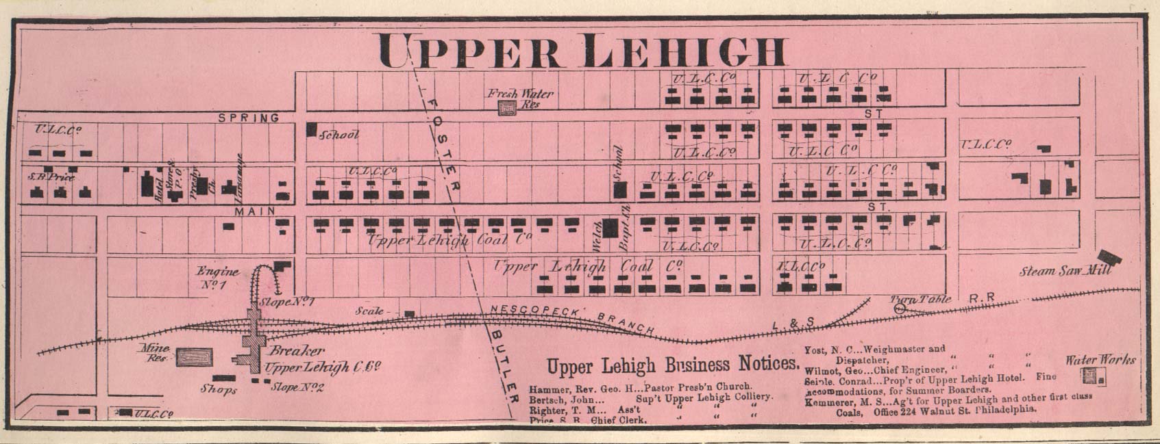 Upper Lehigh - "Upper
Lehigh is an exception to the rule in mining towns, as it is a model of
neatness, presenting the appearance of a tidy New England village. The
property is all owned by the Upper Lehigh Coal Company, and the
stockholders are personally represented in every department of the
work. The village was laid out in 1865 into regular streets and blocks,
and the miners' houses, 205 in number, making 410 tenements of that
class, are substantially built upon solid foundations, and are of a
uniform size and neatly painted. The streets are broad and are kept
scrupulously clean, as no rubbish of any kind is allowed to be
deposited in the streets or alleys. The houses of the proprietors,
superintendent, chief clerk and foreman are of modern architecture, and
are painted a different color than those of the miners. The town is
about 700 feet higher than the Lehigh at White Haven, and is approached
from the east by the Nescopeck branch of the Central Railroad of New
Jersey, which was built to this place in 1867. The first building put
up was the steam saw-mill, which was built in the fall of 1865 and
commenced running that winter; in the spring of 1866 the company built
25 double homes, making 50 tenements. The first school-house, the
double one on the Foster side of the line, was built in 1867, the
second one in 1870, and the third one in 1876. The last two are on the
Butler side of the line. George W. Kemmerer was appointed postmaster in
1867. At first the mails were received from Eckley; they are now
received daily by the railroad. H. M. Merrick is the postmaster. In
1866 the company built a first class machine shop, where all its own
work is done from the raw material. The company store, the only one
here, was built in 1866. The Upper Lehigh Hotel, built by the Upper
Lehigh Coal Company, was opened for the reception of guests January
28th, 1869, by Conrad Seiple as manager. This is the only hotel in the
place. The village is well supplied with pure spring water from the
reservoir on the north side, above the double school-house. The water
is carried in pipes to all parts of the town, and to the breakers. The
Upper Lehigh cemetery was laid out into lots in 1866. ... There are at
this place two churches (Presbyterian and Welsh) and a Methodist
Episcopal society without a church; a store, three school-houses and
four schools, a hall, a shoemaker, and 1,400 inhabitants. The mines
were opened by the Upper Lehigh Coal Company in the summer of 1866, and
the first shipment of coal was made in March, 1867." [read more about
Upper Lehigh 1880]
Upper Lehigh - "Upper
Lehigh is an exception to the rule in mining towns, as it is a model of
neatness, presenting the appearance of a tidy New England village. The
property is all owned by the Upper Lehigh Coal Company, and the
stockholders are personally represented in every department of the
work. The village was laid out in 1865 into regular streets and blocks,
and the miners' houses, 205 in number, making 410 tenements of that
class, are substantially built upon solid foundations, and are of a
uniform size and neatly painted. The streets are broad and are kept
scrupulously clean, as no rubbish of any kind is allowed to be
deposited in the streets or alleys. The houses of the proprietors,
superintendent, chief clerk and foreman are of modern architecture, and
are painted a different color than those of the miners. The town is
about 700 feet higher than the Lehigh at White Haven, and is approached
from the east by the Nescopeck branch of the Central Railroad of New
Jersey, which was built to this place in 1867. The first building put
up was the steam saw-mill, which was built in the fall of 1865 and
commenced running that winter; in the spring of 1866 the company built
25 double homes, making 50 tenements. The first school-house, the
double one on the Foster side of the line, was built in 1867, the
second one in 1870, and the third one in 1876. The last two are on the
Butler side of the line. George W. Kemmerer was appointed postmaster in
1867. At first the mails were received from Eckley; they are now
received daily by the railroad. H. M. Merrick is the postmaster. In
1866 the company built a first class machine shop, where all its own
work is done from the raw material. The company store, the only one
here, was built in 1866. The Upper Lehigh Hotel, built by the Upper
Lehigh Coal Company, was opened for the reception of guests January
28th, 1869, by Conrad Seiple as manager. This is the only hotel in the
place. The village is well supplied with pure spring water from the
reservoir on the north side, above the double school-house. The water
is carried in pipes to all parts of the town, and to the breakers. The
Upper Lehigh cemetery was laid out into lots in 1866. ... There are at
this place two churches (Presbyterian and Welsh) and a Methodist
Episcopal society without a church; a store, three school-houses and
four schools, a hall, a shoemaker, and 1,400 inhabitants. The mines
were opened by the Upper Lehigh Coal Company in the summer of 1866, and
the first shipment of coal was made in March, 1867." [read more about
Upper Lehigh 1880]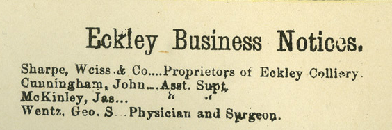
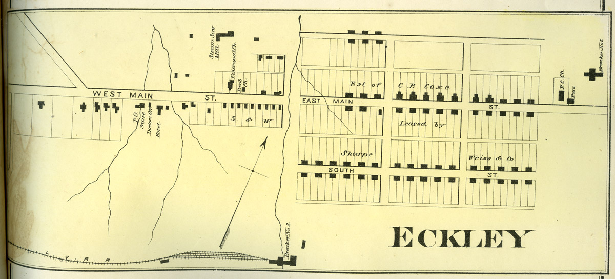 Eckley
- Eckley first came into public notice in 1854, when Messrs. Sharp,
Leisenring & Weiss opened the coal mines here. A branch of the
Lehigh Valley Railroad was built to this place in 1855, and a shipment
of coal was made in September of that year. A large and commodious
hotel was built here in 1857, and subsequently converted into a
dwelling house. The school-house was built in 1858, and the steam
saw-mill in 1856. The Protestant Episcopal and Presbyterian churches
were built in 1858, and since then the Catholic church. The population
is about 600. E. T. Dodson is the present postmaster.
Eckley
- Eckley first came into public notice in 1854, when Messrs. Sharp,
Leisenring & Weiss opened the coal mines here. A branch of the
Lehigh Valley Railroad was built to this place in 1855, and a shipment
of coal was made in September of that year. A large and commodious
hotel was built here in 1857, and subsequently converted into a
dwelling house. The school-house was built in 1858, and the steam
saw-mill in 1856. The Protestant Episcopal and Presbyterian churches
were built in 1858, and since then the Catholic church. The population
is about 600. E. T. Dodson is the present postmaster.The colliery at this place is known as Council Ridge Colliery, and is owned by the estate of Tench Coxe, and operated by J. Leisenring & Co. At slope No. 2 there are 160 men and boys employed under ground, and 70 on the surface. There are eight engines, with a total of 375 horse power. At No. 5 there are 77 men employed under ground, and 44 on the surface. There are seven engines, of 375 horse power. The number of tons of coal mined in 1878 for both slopes was 143,884.
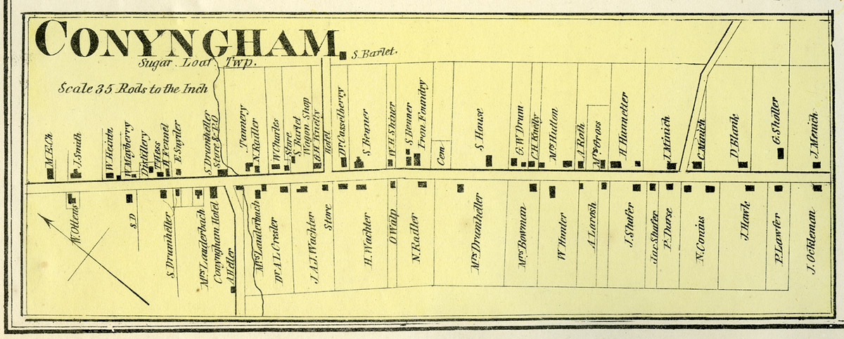 Conyngham
- This town plot was surveyed as early as 1806. ... The first tavern at
Conyngham was built on the site of the Conyngham Hotel in 1815. It was
partly of logs and partly framed. Soon afterward Samuel Harmon built a
tavern of hewn logs on the site of the Phoenix Hotel. He had a trout
pond in the rear where William Charles's store now stands.
Conyngham
- This town plot was surveyed as early as 1806. ... The first tavern at
Conyngham was built on the site of the Conyngham Hotel in 1815. It was
partly of logs and partly framed. Soon afterward Samuel Harmon built a
tavern of hewn logs on the site of the Phoenix Hotel. He had a trout
pond in the rear where William Charles's store now stands.Mr. Harmon was the first postmaster. William Drum kept the office in 1830, where C. H. Kneely now lives. A tannery on the site of Nathan Radler's larger establishment was built in 1820 by a Mr. Lomison. The iron foundry was built in 1842 by M. Hutton and is now owned by James Getting. ... During the spring of 1880 the Black Ridge Coal Company was engaged in "proving coal" near Conyngham station, preparatory to putting up a breaker. The company owns two 400-acre tracts. The westerly one contains Conyngham station. Coxe Bros. & Co. were lately building a wagon road from the Conyngham Station road to Gowen. They control all the land, except one tract at Tomhicken, for nearly 15 miles westward from the Conyngham station tract, and are sinkinog a slope just east of Tomhicken. ...
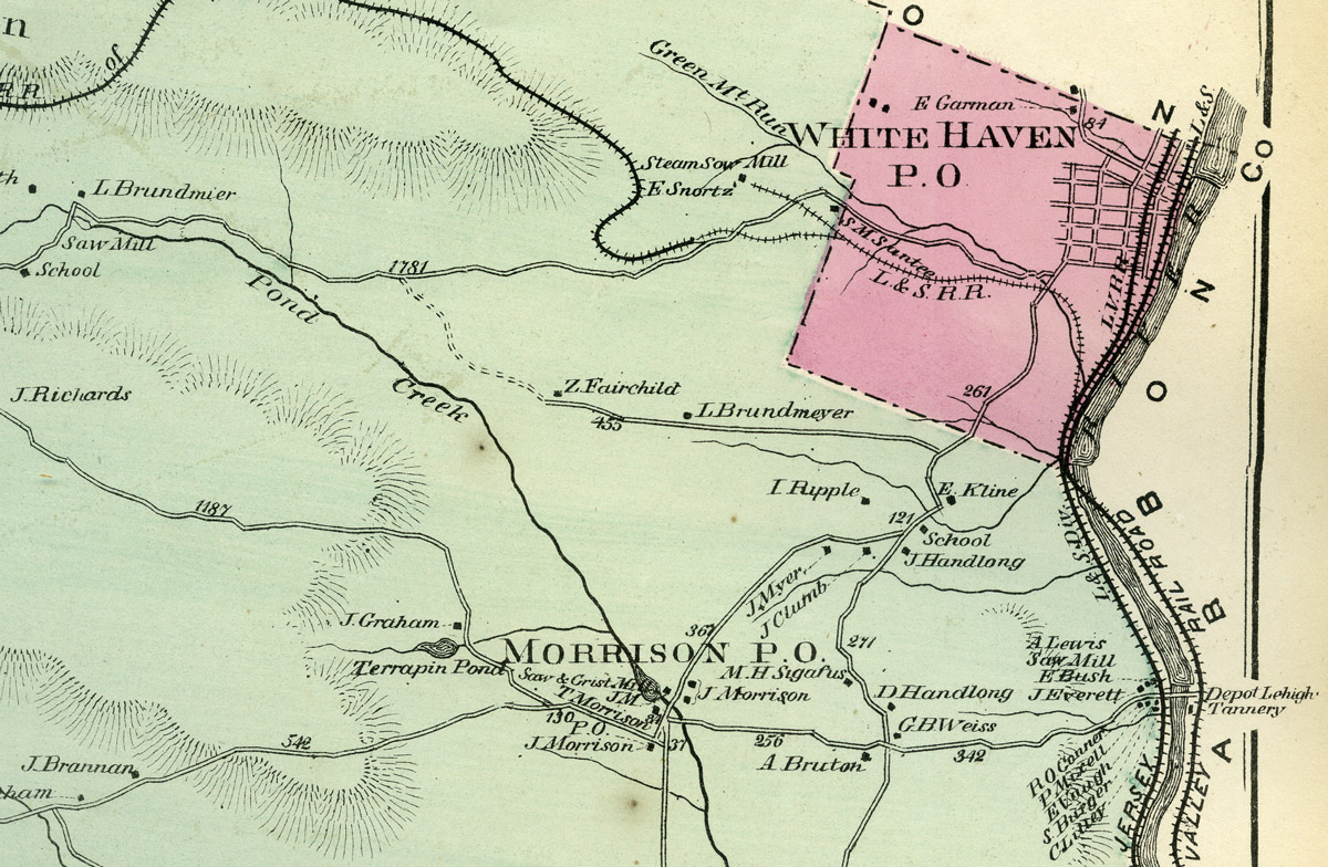
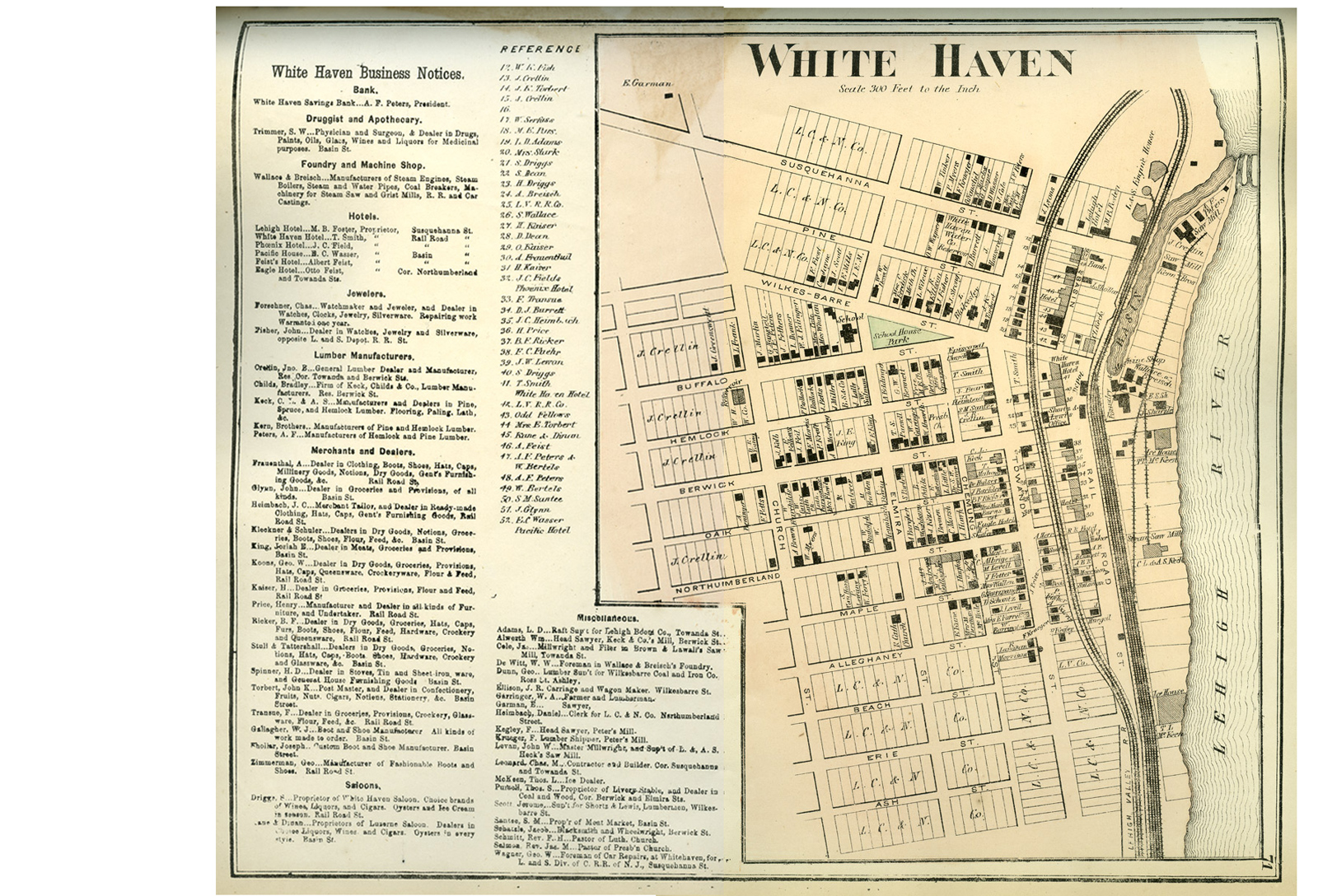 White Haven - White Haven was first
settled in 1824, by John Lines, and named in honor of Josiah White, who
was an early, prominent and enterprising citizen and the builder of the
old fashioned "bear trap" locks that made the Lehigh navigable as far
above here as Stoddardsville, and were in use as late as 1860 when the
old Lehigh Navigation and Coal Company used the river above and the
so-called canal below White Haven as a means of transportation. ... At
that time the hills on either side of the river at this place were
thickly covered with pine timber, that would now be considered very
valuable. The company as soon as possible, and even before the canal
was finished, built a saw-mill near the upper end of the basin, on the
river side, and cut out the lumber necessary in building the original
dam across the river a little above where the Lehigh Valley Railroad
crosses. Other saw-mills were soon built, and in a short time White
Haven was one of the busiest lumber depots in the State.
White Haven - White Haven was first
settled in 1824, by John Lines, and named in honor of Josiah White, who
was an early, prominent and enterprising citizen and the builder of the
old fashioned "bear trap" locks that made the Lehigh navigable as far
above here as Stoddardsville, and were in use as late as 1860 when the
old Lehigh Navigation and Coal Company used the river above and the
so-called canal below White Haven as a means of transportation. ... At
that time the hills on either side of the river at this place were
thickly covered with pine timber, that would now be considered very
valuable. The company as soon as possible, and even before the canal
was finished, built a saw-mill near the upper end of the basin, on the
river side, and cut out the lumber necessary in building the original
dam across the river a little above where the Lehigh Valley Railroad
crosses. Other saw-mills were soon built, and in a short time White
Haven was one of the busiest lumber depots in the State. The first school-house in the borough was built in 1838, of rough logs, and stood in the rear of where C. Kleckner's store now stands, on Basin street. The site is occupied by the track of the Lehigh Valley Railroad. ... The pioneer store was kept by A. O. Chahoon. It was of rough logs, was built in 1835, and stood at the lower end of Susquehanna street, near where the Lehigh Hotel formerly stood. The nearest trading points at that time were Wilkes-Barre, Berwick and Mauch Chunk. ... The post-office was established in 1835, with William Hoven as postmaster. It was kept in the old log store at the foot of Susquehanna street. The mails were brought on horseback once a week from Wilkes-Barre. ...
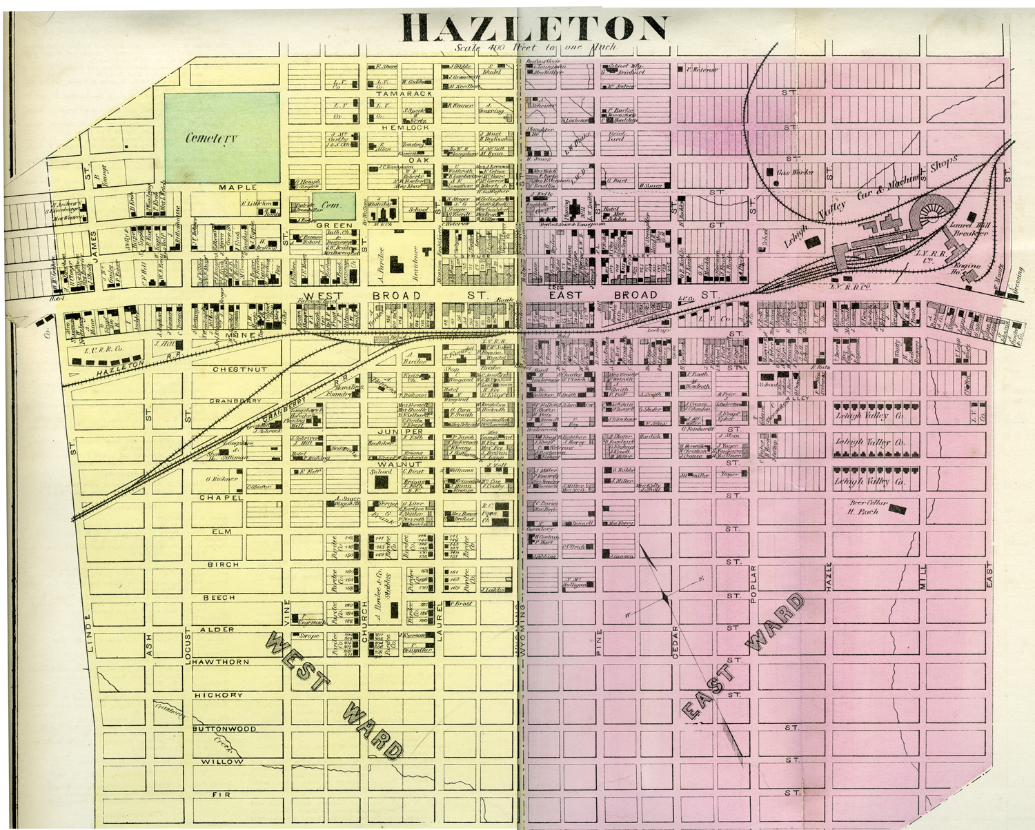
Hazleton -
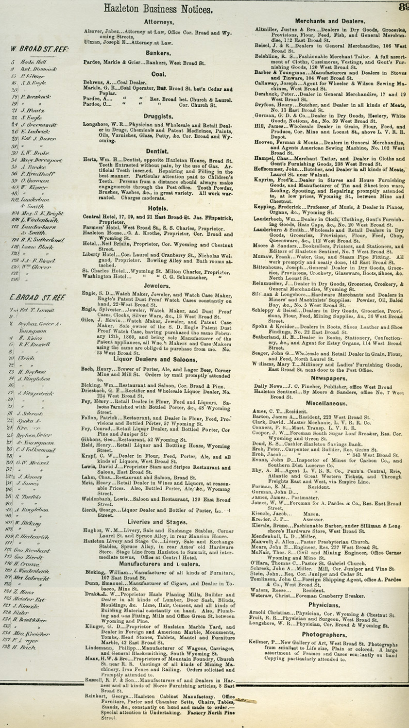
 This is the largest and most
enterprising town in the middle coal field region. It is on a broad
table land, 1,700 feet above tide water. The borough is abundantly
supplied with pure spring water by the Hazleton Water Company. The
water is obtained upon one of the hills southeast of the town and
conveyed in terra cotta pipes. The altitude of Hazleton, the purity of
the air and water, with the perfect system of sewerage and drainage and
the enforcement of strict sanitary measures, make it one of the
exceedingly healthy towns of the State. The water company has in course
of construction an artesian well, which when completed will add largely
to the water supply.
This is the largest and most
enterprising town in the middle coal field region. It is on a broad
table land, 1,700 feet above tide water. The borough is abundantly
supplied with pure spring water by the Hazleton Water Company. The
water is obtained upon one of the hills southeast of the town and
conveyed in terra cotta pipes. The altitude of Hazleton, the purity of
the air and water, with the perfect system of sewerage and drainage and
the enforcement of strict sanitary measures, make it one of the
exceedingly healthy towns of the State. The water company has in course
of construction an artesian well, which when completed will add largely
to the water supply.There are located at this place the locomotive and machine shops of David Clark, the extensive burial casket manufactory of L. W. Drake, the wholesale furniture manufacturing establishment of G. Reinhart, the Mountain foundry of H. W. Montz & Brother, the Phoenix planing mill of John Daniels, the Hazleton lime kilns of Casper Shaffer, several carriage, wagon and sleigh manufactories, and the Lion brewery, all of which employ annually a large number of men, and whose pay rolls aggregate annually over $1,000,000. There are also a large number of extensive dry goods, grocery, hardware, clothing and drug stores, cigar factories, and many other business concerns. The principal hotels are the Central and Hazleton. There are nine churches, with an aggregate membership of 5,789. There are twenty-one schools within the limits of the borough. Hazleton has also four weekly and two daily newspapers. The population of the borough is 6,893, against 4,317 in 1870. James James is the present postmaster. ...
The borough was incorporated in accordance with an act approved April 3d, 1851, and a supplemental act approved April 22nd, 1856. The first election for borough officers was held at the hotel of Thomas Lawall, on the corner of Broad and Wyoming streets, where the Hazleton House now stands, on the 27th of March, 1857 …
December 11th, 1869, the boundaries of the borough were enlarged so as to take in the lands of William Kortz and forty-nine other proprietors, lying between the lands of the Lehigh Valley Railroad Company and the Diamond Coal Company, northwest of the old boundary line. …
Townships
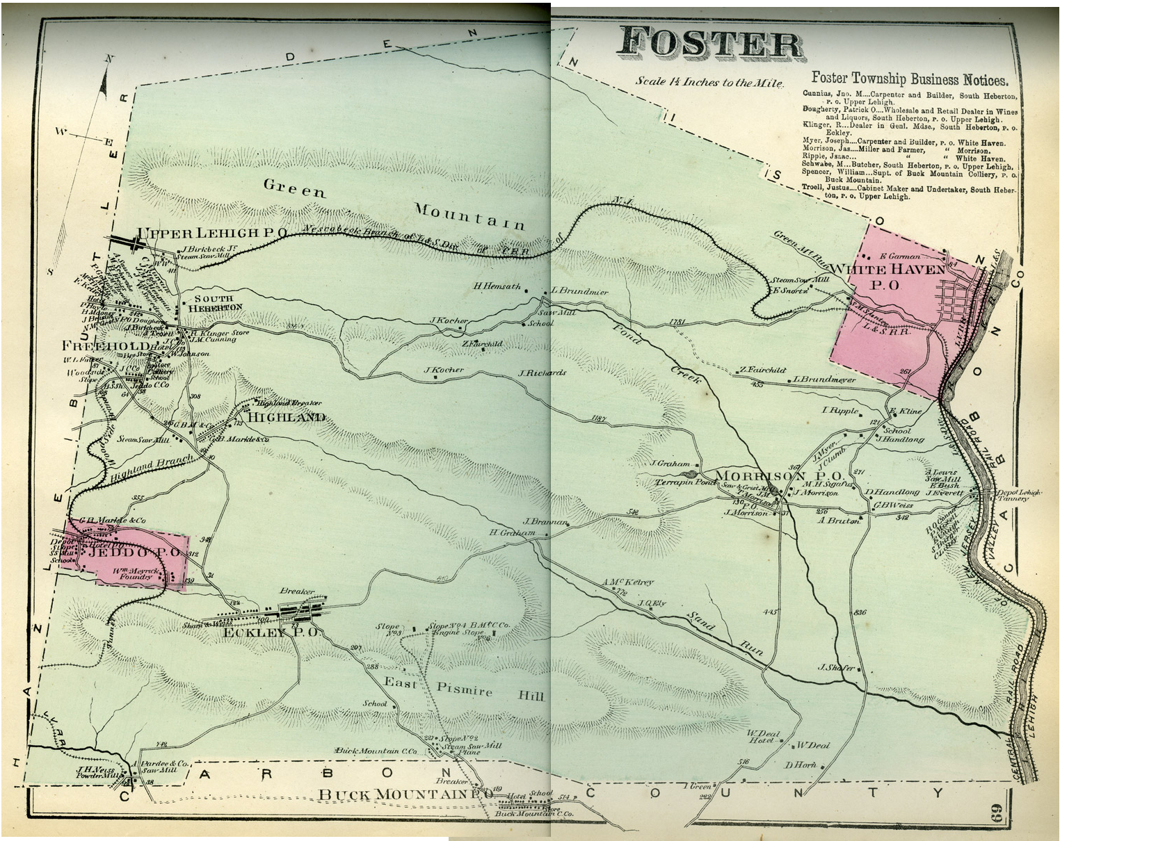 Foster - On November
15th, 1855, this township was set off from Denison and named after A.
L. Foster, Esq., the principal early benefactor of the village of
Eckley. It is noted for the excellent quality and large quantity of
coal produced at its mines. John Lines was the pioneer settler. Besides
his garden patch where he first located he cleared a piece of land at
Terrapin Pond, about three miles southwest, and raised the first farm
crop in this township. At that time Foster was not surveyed into lots,
but was an unbroken and almost unknown wilderness, filled with wild
beasts. The nearest neighbor was at Lowerytown, now Rockport, seven
miles down the river, and visiting, especially in the evening, was a
rare luxury.
Foster - On November
15th, 1855, this township was set off from Denison and named after A.
L. Foster, Esq., the principal early benefactor of the village of
Eckley. It is noted for the excellent quality and large quantity of
coal produced at its mines. John Lines was the pioneer settler. Besides
his garden patch where he first located he cleared a piece of land at
Terrapin Pond, about three miles southwest, and raised the first farm
crop in this township. At that time Foster was not surveyed into lots,
but was an unbroken and almost unknown wilderness, filled with wild
beasts. The nearest neighbor was at Lowerytown, now Rockport, seven
miles down the river, and visiting, especially in the evening, was a
rare luxury.About 1840 Thomas Morrison came in from the valley and located on Pond creek, three miles south of White Haven. Here he built two saw-mills and a grist-mill. The timber was soon exhausted and the saw-mills went to decay. Soon after Mr. Morrison settled he was appointed post-master, and the little settlement became known as Morrison's post-office. ... The population of the township in 1880 was 5,118, against 3,000 in 1870. [read more about Foster Township 1880]

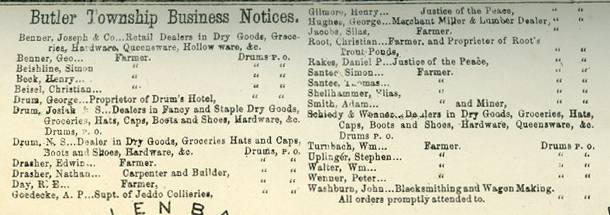 Butler - This township
was taken from Sugarloaf at the August sessions of 1839. Part was
annexed to Hazle November 30th, 1861. Upon the banks of the streams
have been and are still quite a number of mills and manufacturing
establishments, while many have gone to decay. ... As soon as peace was
assured to settlers they began to make permanent settlements in this
beautiful valley. From the very favorable reports brought back by the
party of men sent out to bury the victims of the Sugarloaf massacre,
others were induced to journey to this new Eldorado. ... The pioneer
saw and grist mills on the Little Nescopeck creek, in the southwestern
part of the township, were built by Redmond Conyngham. The saw-mill was
built in 1809 on lands now owned by N Beishline, and went to decay many
years ago. The grist-mill was built in 1814 on the opposite side of the
creek, where Silas Jacobs now lives, and is now owned by Charles
Knelley. The pioneer saw-mill on the Big Nescopeck creek, in the
northeastern part of the township, was built in 1813 by Samuel
Woodring, near the site now occupied by A. Straw & Son's saw-mill;
and in 1820 Redmond Conyngham built a grist-mill on the site now
occupied by Straw's saw-mill. The pioneer carding-mill was buit about
1810 at what is now Ashville, on the Little Nescopeck creek, on the
Linderman property; and the first woolen-mill was built in 1835 by
Philip Drum, on the Little Nescopeck, a short distance above Ashville.
Butler - This township
was taken from Sugarloaf at the August sessions of 1839. Part was
annexed to Hazle November 30th, 1861. Upon the banks of the streams
have been and are still quite a number of mills and manufacturing
establishments, while many have gone to decay. ... As soon as peace was
assured to settlers they began to make permanent settlements in this
beautiful valley. From the very favorable reports brought back by the
party of men sent out to bury the victims of the Sugarloaf massacre,
others were induced to journey to this new Eldorado. ... The pioneer
saw and grist mills on the Little Nescopeck creek, in the southwestern
part of the township, were built by Redmond Conyngham. The saw-mill was
built in 1809 on lands now owned by N Beishline, and went to decay many
years ago. The grist-mill was built in 1814 on the opposite side of the
creek, where Silas Jacobs now lives, and is now owned by Charles
Knelley. The pioneer saw-mill on the Big Nescopeck creek, in the
northeastern part of the township, was built in 1813 by Samuel
Woodring, near the site now occupied by A. Straw & Son's saw-mill;
and in 1820 Redmond Conyngham built a grist-mill on the site now
occupied by Straw's saw-mill. The pioneer carding-mill was buit about
1810 at what is now Ashville, on the Little Nescopeck creek, on the
Linderman property; and the first woolen-mill was built in 1835 by
Philip Drum, on the Little Nescopeck, a short distance above Ashville. 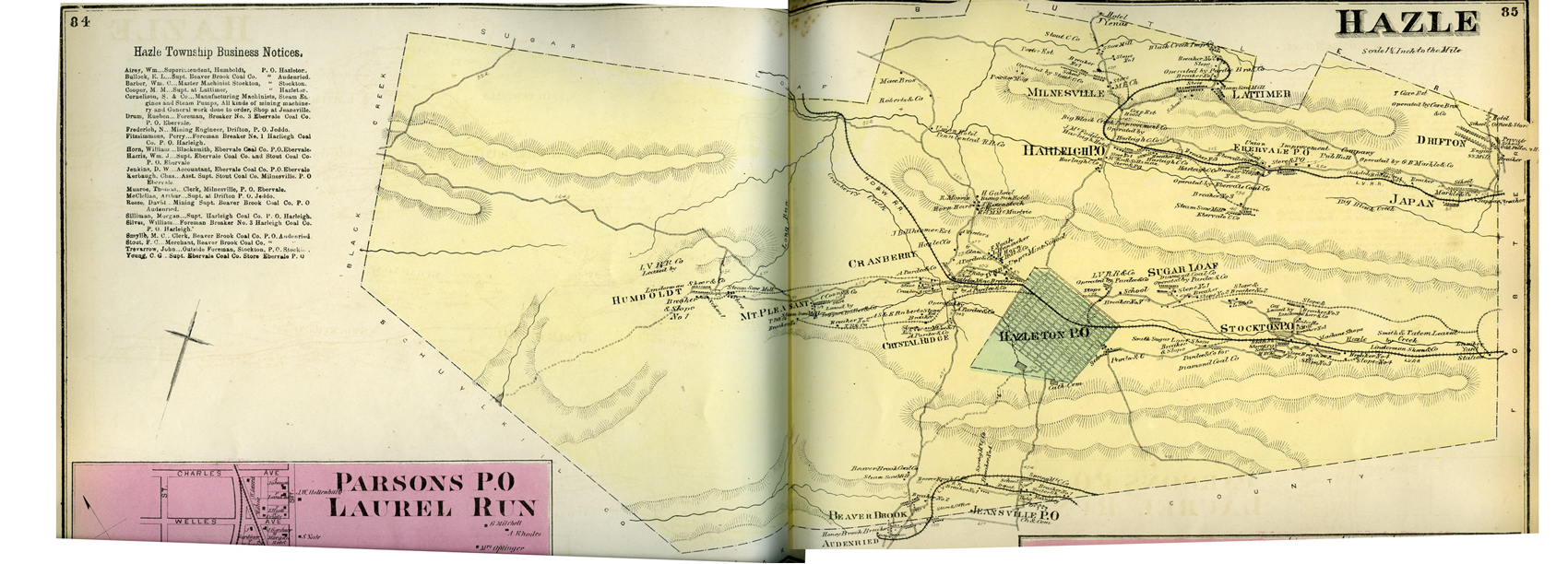 Hazle
- This township was taken from Sugarloaf in August, 1839, and a part of
Butler was added to it November 6th, 1856. The Township derives its
name from Hazle creek, which rises on the east border of Hazleton; and
it is said that the creek was so named from the fact that many hazel
bushes greew on its banks near its source.
Hazle
- This township was taken from Sugarloaf in August, 1839, and a part of
Butler was added to it November 6th, 1856. The Township derives its
name from Hazle creek, which rises on the east border of Hazleton; and
it is said that the creek was so named from the fact that many hazel
bushes greew on its banks near its source. The Hazleton mine, just west of the borough limits, was opened in 1836. Soon after this other mines were opened, and in a short time this coal basin, number 3, became a vast mining district, and soon afterward basin number 4, north of Council ridge, on the Big Black creek, was explored and found to contain large quantities of the black diamonds. As soon as coal was discovered, the population of the township began to increase and mining villages sprung up. In 1804 the Lehigh and Susquehanna Turnpike Company was chartered, and soon afterward the road was surveyed and laid out 100 feet wide, from Mauch Chunk to Berwick, the route running through this township. That portion of it running through Hazleton now forms East and West Broad streets. This was the first road laid out in the township.
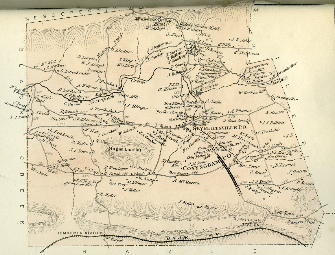 Sugarloaf - This
township derives its name from Sugarloaf mountain It was formed from
Nescopeck in April, 1809, and formerly embraced the townships of Butler
and Hazle, which were taken off in August, 1839, and Black Creek, which
was taken off August 8th, 1848. The population in 1879 was 1,240 and in
1880 1,390.
Sugarloaf - This
township derives its name from Sugarloaf mountain It was formed from
Nescopeck in April, 1809, and formerly embraced the townships of Butler
and Hazle, which were taken off in August, 1839, and Black Creek, which
was taken off August 8th, 1848. The population in 1879 was 1,240 and in
1880 1,390.Settlement began between 1775 and 1780, although grants of land had been given as early as 1769. ...
The first carding-mill was built by Abraham Stahr in 1814, on the farm now owned by Mrs. Engle. There was also a saw-mill at the same place. Both have gone to decay. About 1809 there was a carding-mill on the northeast side of the Little Nescopeck, where it crosses the Butler road from Conyngham. There was also a saw-mill, the foundations of which are still visible.
The first farm cleared to any extent was William Seiwell's, and Mrs. Engle's the next.
The first road through the town was made, or rather called a road, before 1800. It was the Owens road, from Berwick to Mauch Chunk, and passed through the farm now owned by William Seiwell. The next road of any importance, the Lehigh and Susquehanna turnpike, from Berwick to Mauch Chunk, was chartered March 19th, 1804, and constructed about 1810. It must have been surveyed between 1804 and 1808, as lots in the village of Conyngham were bounded by the center of this turnpike. The first bridge was where the turnpike crosses the Nescopeck.
The grist-mill now owned by Mrs. Jesse Johnson, south of Seybertsville, was built in 1820 by Goerge Koenig. Benjamin Koenig built one at Seybertsville, on the Little Nescopeck, in 1815, and Richard Allen built a saw-mill above the site of the grist-mill in 1798. They both went to decay many years ago. The first blacksmith, Jacob Mace, lived on the farm now owned by William Seiwell, and was one of the first settlers. The next blacksmith, a Mr. Law, lived on the Black Creek road from Conyngham. The first shoemaker was George Rupert. He lived near the west line of the township. The first brick house was built by Daniel Brown, and it is now part of the Brown estate. The first steam mill in this township was ubilt by Stephen Yost in 1865, on the road from Black Creek to Conyngham. ...
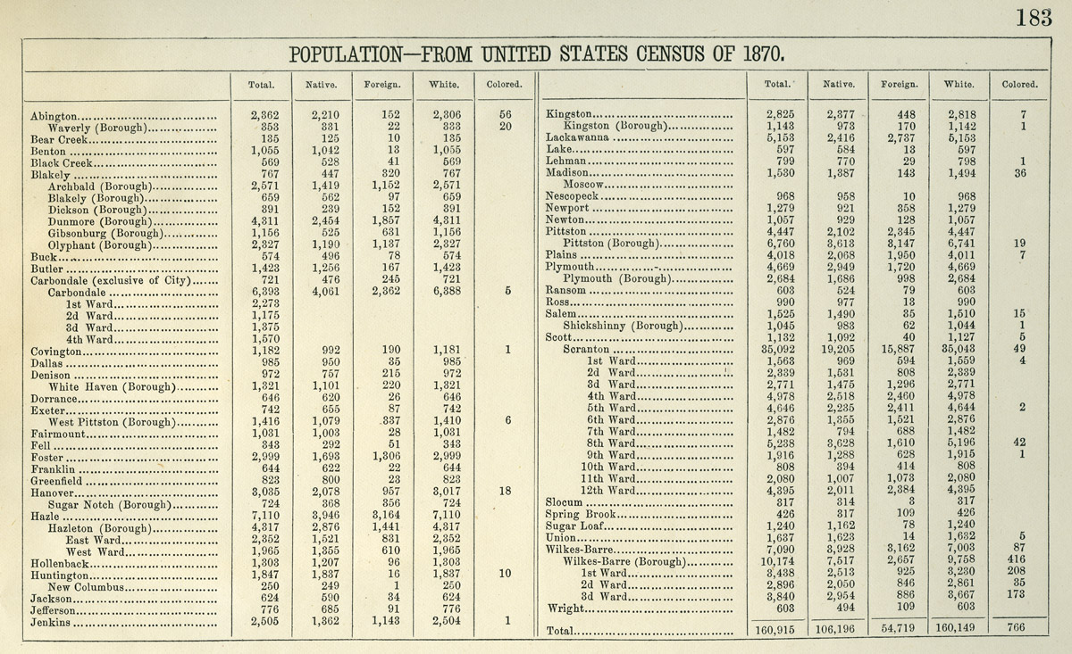
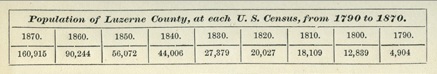
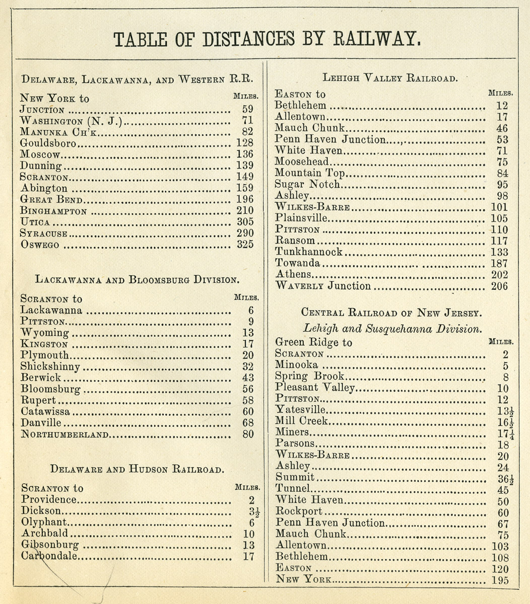
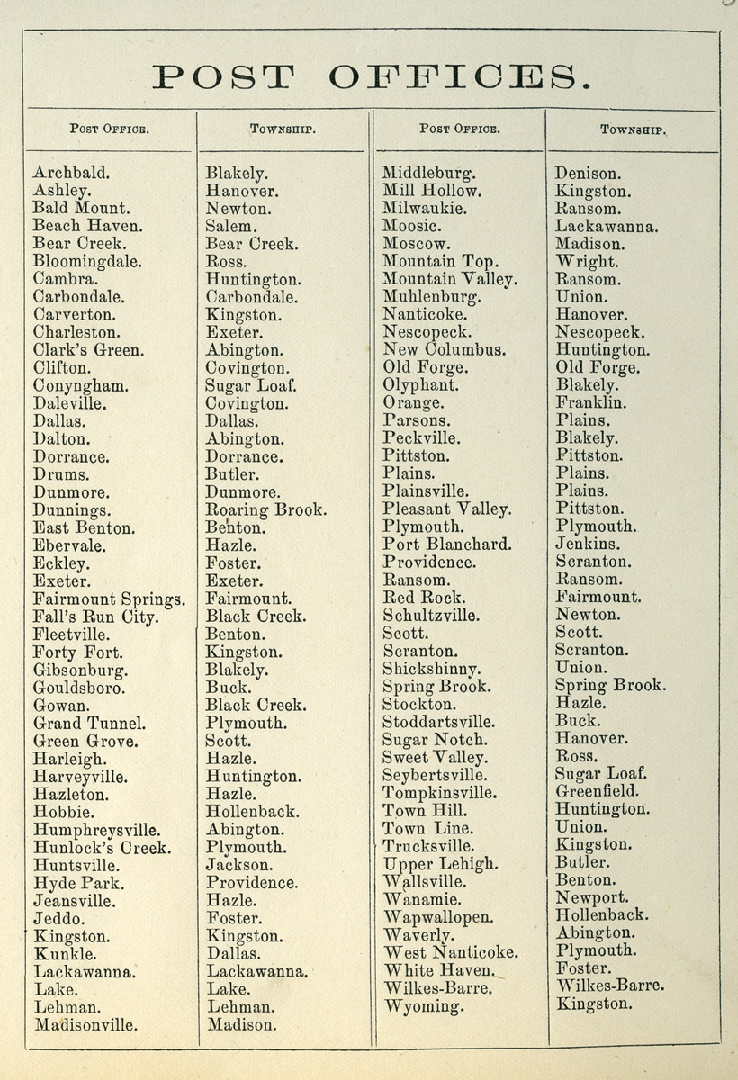
Supplemental information - The 1873 Atlas also included 1870 population figures for many of the communities, total Luzerne County population figures 1790-1870, a table of railway distances, and a list of post offices.