News & announcements
Saving your history
Early accounts
Maps
Nearby towns
People
Churches
Schools
Municipal
Organizations
Businesses
The mines
Transportation
Streets
Buildings
Entertainment
Celebrations
Sports
Ethnic groups
Buck Mountain
What's on this page:
- UPDATE - New edition of
Buck Mountain book, and offer to trade new edition for old at no charge
- Maps from D. G. Beers' Atlas of Luzerne County, Pennsylvania (1873)
- Email conversations about Buck Mountain
- Description of Buck Mountain in Bob Falatko’s History of
Foster Township
- Geological Survey of Pennsylvania map, Eastern Middle Coal Field Mine Sheet No. VI, 1888
- Abandoned
Buck Mountain Coal Company gravity railroad tunnel
A lot of research for this page was done by Joe Moore, who has been talking to people, looking at old maps and searching for more maps online – he found the Penn State digitized Geological Survey 1888 map and the gravity railroad tunnel video, both linked above. We also have some information from him, Melanie Akren-Dickson and Jean Zimmerman. Ed Merrick found a 1945 Christmas Eve ad for Feissner’s Hotel in Buck Mountain. Bob Falatko did an enormous amount of research for his book, History of Foster Township, which has been out of print for years now. I wish it could be reprinted! I’m quoting his Buck Mountain description here. And I’m highlighting Melanie Akren-Dickson’s new book on people from Buck Mountain and the local area. If you can add to what's here about Buck Mountain, please let me know!
 NEW EDITION of Buck Mountain book, with
revised text, color illustrations, and an index.
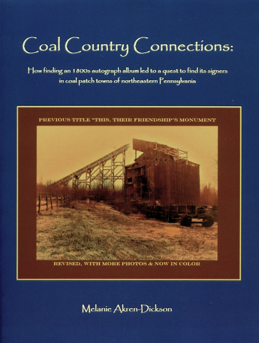
NEW EDITION of Buck Mountain book, with
revised text, color illustrations, and an index."This, Their Friendship's Monument” by Melanie Akren-Dickson came out in 2020, about people in Buck Mountain and the Freeland area. The new edition is called “Coal Country Connections.”
For anyone who bought either version of the earlier book, author Melanie Akren-Dickson offers to swap a copy of the new edition for the old one at no charge. If you would send her your old copy, she will send you the new edition. You don’t have to worry too much about careful packaging because she will just be recycling the old copies. You can get her address by sending her email. Thanks for supporting her in this way.
Melanie Akren-Dickson's book is about her great-great-great-aunt Mary Boyd of Buck Mountain’s autograph album. Found among her grandmother’s effects, the album was signed by 80+ people between 1881 and 1896, when Mary Boyd was age 23-37. Signers included coal miners, schoolteachers, Civil War veterans, even daughters of a Philadelphia magnate of industry, and many familiar names from the region. The album led Melanie to spend years researching the signers and the long-gone village of Buck Mountain. Through family documents and interviews, online resources, public records and other sources she found at least several pieces of information for most of the signers. The book is well illustrated and gives an intriguing view of the lives that intersected in this little autograph album – one of many compelling features of the book being that it documents women of the time as well as men. A treasure trove of local history.
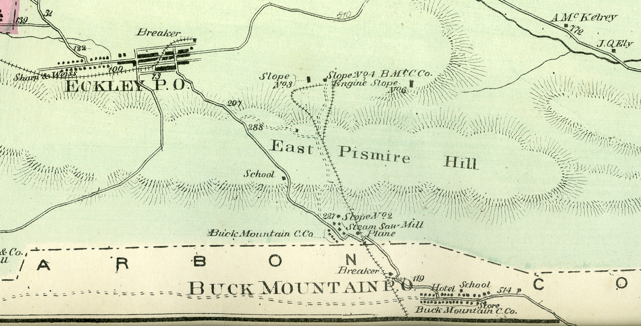
Maps from D. G. Beers' Atlas of Luzerne County, Pennsylvania (1873)
Company
town of Buck Mountain at Slope #2, 1873. Melanie Akren-Dickson, whose
new book about people of Buck Mountain and beyond, is described below,
wrote this to me recently: There was
a second slope for the Buck Mountain Coal Company that was actually
just over the line in Luzerne County, from what I've gathered. There is
a portion of a map on page 73 in my book that shows it (I'll attach it
here). I know about it, because I was confused by it. My
great-times-whatever uncle James McClellan, who was a supervisor at the
mine at Eckley in 1860, was in Foster Township in 1870, post office
Buck Mountain. Then in 1880, the place where the McClellans lived was
called "No. 2 mines Buck Mountain" in Luzerne County.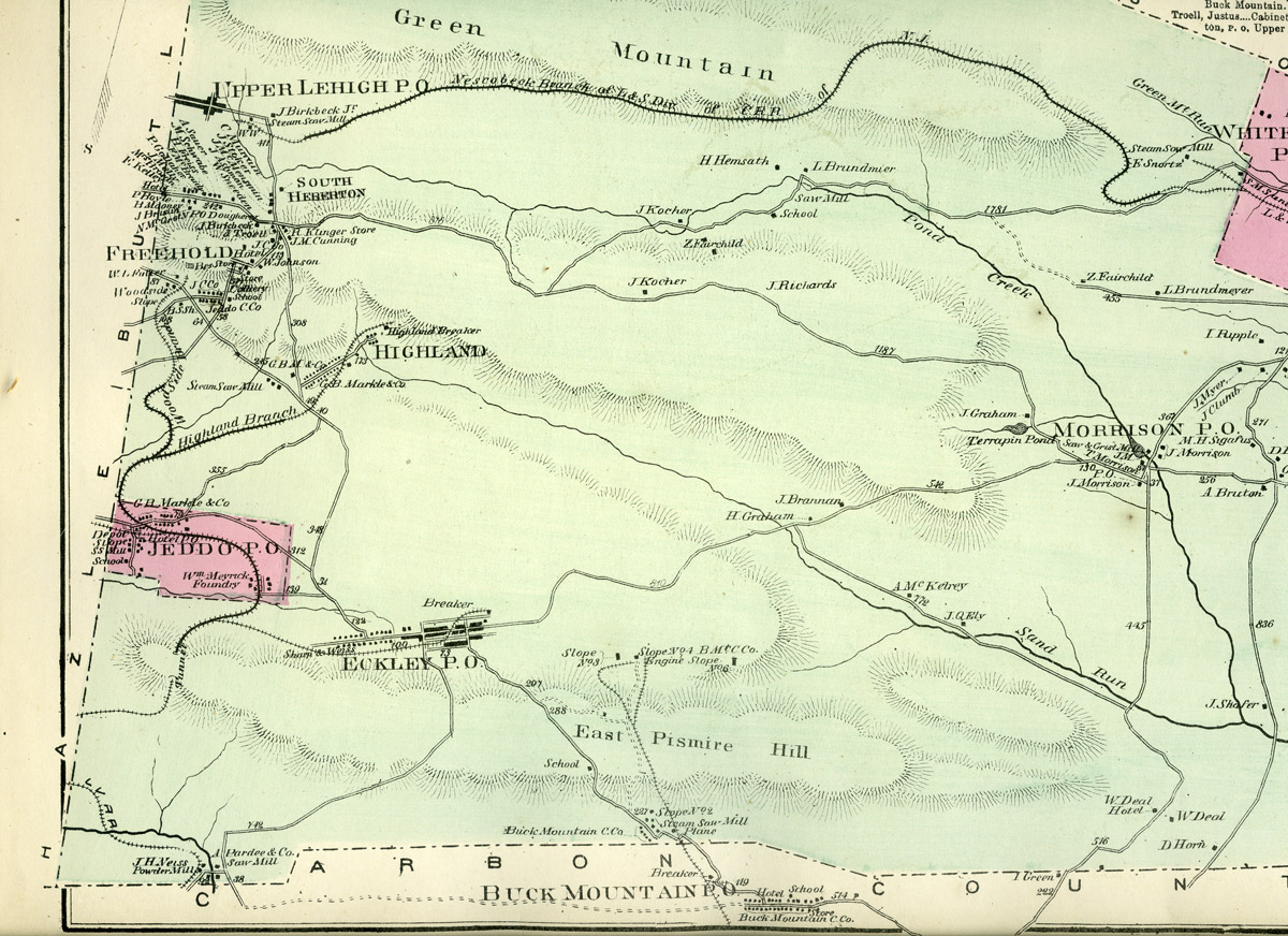 Buck Mountain Slope #2 area in Carbon County near
Foster township, 1873
Buck Mountain Slope #2 area in Carbon County near
Foster township, 1873  Buck
Mountain area in Butler township, 1873
Buck
Mountain area in Butler township, 1873 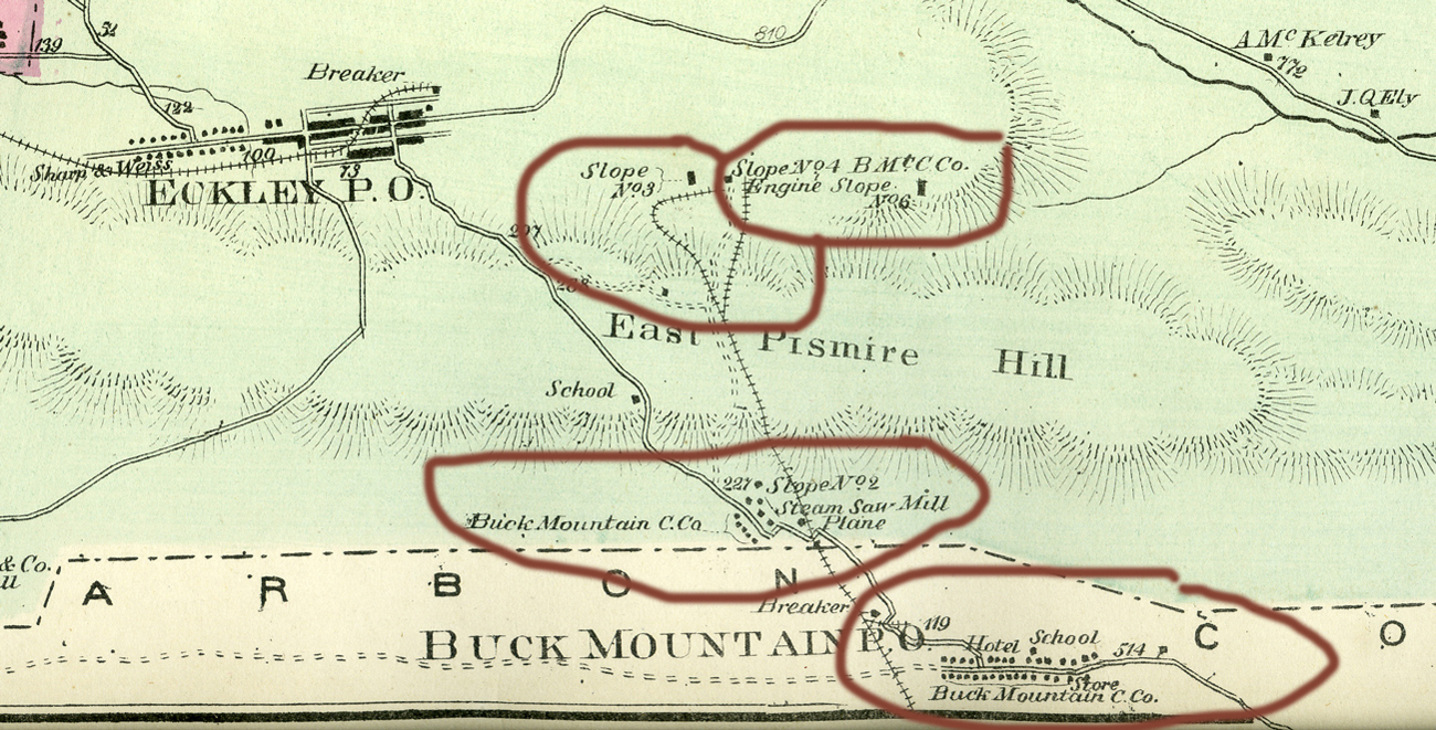 Four
Buck
Mountain areas shown on the Foster township map, 1873
Four
Buck
Mountain areas shown on the Foster township map, 1873 Email conversations about Buck Mountain
Melanie Akren-Dickson:
There was a second slope for the Buck Mountain Coal Company that was actually just over the line in Luzerne County, from what I've gathered. There is a portion of a map on page 73 in my book that shows it. I know about it, because I was confused by it. My great-great-great-great-uncle James McClellan, who was a supervisor at the mine at Eckley in 1860, was in Foster Township in 1870, post office Buck Mountain. Then in 1880, the place where the McClellans live is called "No. 2 mines Buck Mountain" in Luzerne County.
As
far as Buck Mountain on the 1873 map, what it appears to me is that
the main village of Buck Mountain is at the bottom edge of that map, in
Carbon County. But slope No. 2 for Buck Mountain is just over the
county line in Luzerne County, in Foster Township. That 1870 census
record I sent you shows my great-times-four uncle James McClellan and
family living, in Foster Township, post office Buck Mountain. The other
parts of Foster Township on the 1870 census are also described by post
office, like Eckley, Morrison, Upper Lehigh, etc. I looked at
modern-day Foster Township on Google maps and does extend all the way
down to the Carbon County line. I switched to satellite mode to see if
there is any sort of remnant of anything where No. 2 slope was, but
there's nothing but tree tops on the satellite image, and I've never
noticed any sort of remnant structures along that part of the road
between Buck Mountain and Eckley.Joe Moore:
Joe spoke with a friend who grew up in Buck Mountain and who told him that “there were probably eight houses he was aware of on the top/Luzerne county side and he mentioned all the family names he knew but none were McClellans. Also, he said that top section where the houses were located was called #2 but I am sure you already knew that because of the map.” Joe added: “I completely agree that the village at the very bottom in Carbon County is the long-gone village. One of the many maps I looked at last night showed a school also about half way between Eckley and … Buck Mountain #2. I think he said there were about eight houses in the #2 slope area. I would guess it was built as a company town. In a straight line on Google maps the two areas, Buck Mountain #2 and the main village, are less than a mile apart.
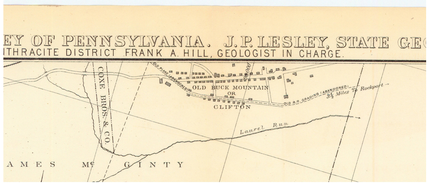 Now
this is interesting... On
a mine map from 1888 they list the name of the larger village as "Old
Buck Mountain OR Clifton!" My question for you is does the OR literally
mean "or" or is it an abbreviation for originally? That's above my pay
grade but it is one more name to keep in mind when searching!”
Now
this is interesting... On
a mine map from 1888 they list the name of the larger village as "Old
Buck Mountain OR Clifton!" My question for you is does the OR literally
mean "or" or is it an abbreviation for originally? That's above my pay
grade but it is one more name to keep in mind when searching!” 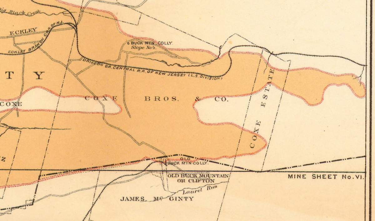 The map
Joe found is part of Penn State’s digital maps collection:
Geological Survey of Pennsylvania. J. P. Lesley, State Geologist.
Beaver Meadow and Dreck Creek Basins, Luzerne and Carbon Counties. Eastern
Middle Coal Field Mine Sheet No. VI. April 1888. Thanks to Penn
State for having and digitizing this and many other old maps, and to
Joe for finding it. Here at right is a larger section of the map that
also shows the Buck Mountain colliery.
The map
Joe found is part of Penn State’s digital maps collection:
Geological Survey of Pennsylvania. J. P. Lesley, State Geologist.
Beaver Meadow and Dreck Creek Basins, Luzerne and Carbon Counties. Eastern
Middle Coal Field Mine Sheet No. VI. April 1888. Thanks to Penn
State for having and digitizing this and many other old maps, and to
Joe for finding it. Here at right is a larger section of the map that
also shows the Buck Mountain colliery.Joe also posted a link on Facebook to a Youtube video posted by The Wandering Woodsman, showing an 1840-1862 abandoned Buck Mountain Coal Company gravity railroad tunnel, in Rockport at Lehigh Gorge State Park.
Jean Zimmerman:
Jean conferred with husband Bob and wrote: We don’t have much info regarding the history of the village of Buck Mountain. I put some questions out on the Weatherly Facebooks seeking someone who might have done a history, or who might have stories to tell about Buck Mountain. We will let you know what (or if) we get any answers.
There are only a few houses left in what was the village. Until recently, the old Buck Mountain still served meals every Thursday evening. No menu. A customer got whatever was cooking on the stove that day. A few months ago the hotel was sold and as far as I know has become a residence for a large family. The church was torn down about 15 years ago.
Ed Merrick:
For your new Buck Mountain page ...
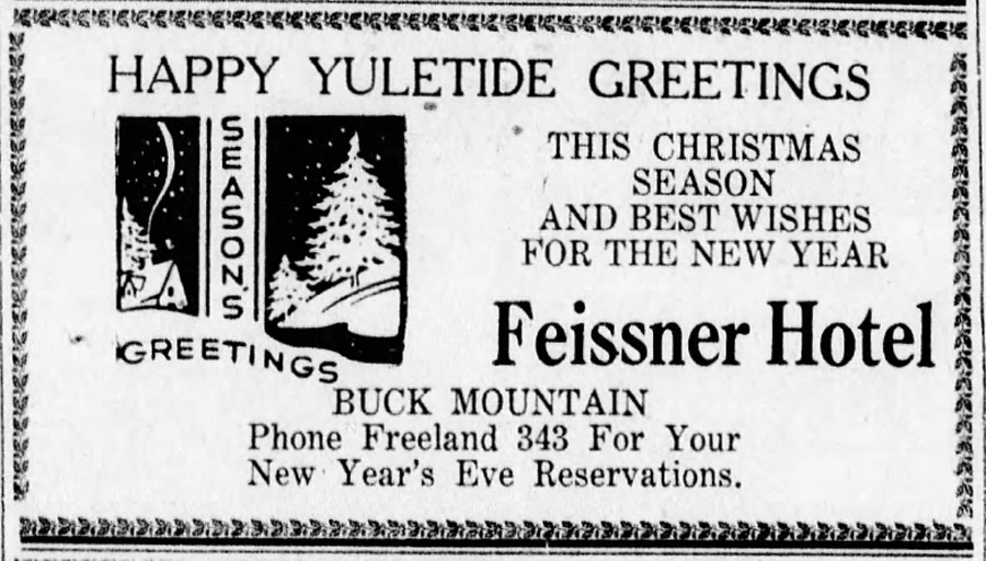
[Note that this was published on Christmas Eve, 1945.]
Buck Mountain, from Bob Falatko’s History of Foster Township, pages 26-28
The Buck Mountain Coal Company was chartered in the year of 1836 by Samuel L. Shoeber, Jacob F. Bunting, Benjamin Kugler, William Richardson, all of whom were Quakers, and Asa Foster. Actual operations began in 1839, and the first coal was shipped in November of 1840. The mines of the operation were located on the summit of Spring Mountain, while the breaker was built at Rockport, five miles away from the site of the mine. A railroad to connect the two locations was built and the loaded cars were run down to Rockport by gravity. For a period of time, a series of five planes conveyed the cars up and down. This method was changed to power by small wood burning locomotives. The breaker was on the banks of Laurel Creek, while its machinery was operated by an ordinary, 25 foot overshot water wheel. With one exception, this was the only breaker in the Anthracite that was operated in this manner. The coal was shipped to market from the Rockport site on the canal. A flood, in 1862, destroyed the canal from Rockport to below White Haven. After the flood, the Hazleton Coal Company built a railroad to the site of the Buck Mountain mines and it was this route that was used from then on. This road was connected to the Lehigh Valley Railroad at Hazle Creek Junction, 2 miles form Weatherly.
In 1843, Buck Mountain had two schools, a company store, a post office, and a hotel. The coal from the Buck Mountain site was of the finest grade and was used by the United States navy in the Civil War, because it was an excellent burner and it gave off very little smoke. This was an excellent way to conceal ships and made them less of a target for the enemy. Erricson's "Monitor", in her now famous battle with the Rebel Ironside, "Merrimac", carried Buck Mountain coal for her fuel. In theyear of 1880, the population of Buck Mountain was 644. In the year 1883, the mines at Buck Mountain were abandoned because it was believed that the high grade coal found in the area had been exhausted. The site was then purchased by Coxe Brothers and Company for the sum of $22,000.00 but they let the mines remain idle and, as a result of this idleness, what had once been a thriving town became a deserted village. In 1895 the stripping of the entire Buck Mountain No. 1 was under consideration. Instead, the mines were worked with the miners who lived in the village of Eckley. The company built a railroad from Buck Mountain to the Eckley breaker. Today, Buck Mountain is only a shell of its former self. A break in the wheel of history.
[Bob’s history includes four photos: a plaque from the Buck Mountain Hotel “since 1810”, just down off the mountain from Eckley; Steve Yasensky of Buck Mountain in his miner’s clothing; the Buck Mountain trap range around the turn of the last century; and the back of the Yasensky home, with two women from that family.]